Tepezalá geodata
Tepezalá (Aguascalientes) is a seat of a second-order administrative division; located in Mexico in America/Mexico_City (GMT-6) time zone. With population of 4,511 people, there are 2039 cities with bigger population in this country. Compared to other cities in Mexico, 85.3% of cities are located further ↓South; 81.8% of cities are located further →East and 79.2% of cities have lower elevation than Tepezalá. Note1


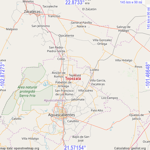
Tepezalá GPS coordinates[2]
22° 13' 26.148" North, 102° 10' 10.56" West
| Map corner | latitude | longitude |
|---|---|---|
| Upper-left | 22.8733°, | -102.87273° |
| Center: | 22.22393°, | -102.1696° |
| Lower-right: | 21.57154°, | -101.46648° |
| Map W x H: | 144.7×144.7 km | = 89.9×89.9mi |
| max Lat: | 32.7° ⇑14.7% North |
| Tepezalá: | 22.22393° |
| min Lat: | ⇓85.3% South 14.53588° |
| min Long | Tepezalá | max Long |
| -117.105° | -102.1696° | -86.73105° |
| W 18.2%⇐ | ⇒81.8% E |
Elevation
Elevation of Tepezalá is 2121 m = 6959 ft, and this is 867.3 m = 2845 ft above average elevation for this country.
| Max E: |
3497 m = 11473 ft | 20.8% |
| Tepezalá | 2121 m 6959 ft | |
| Avg. | 1253.7 m = 4113 ft | |
Min E: |
-1 m = -3 ft | 79.2% |
See also: Mexico elevation on elevation.city.
Geographical zone
Tepezalá is located in North Torrid zone (between Equator and Tropic of Cancer). Distance of this Northern Tropic circle is 134.8 km =83.8 mi to North.| Distance of | km | miles | from Tepezalá |
|---|---|---|---|
| North Pole | 7536 | 4682.7 | to North |
| Arctic Circle | 4930.1 | 3063.4 | to North |
| Tropic Cancer | 134.8 | 83.8 | to North |
| Equator | 2471.1 | 1535.5 | to South |


Nearby cities:
15 places around Tepezalá: (largest is in red/bold)
• Asientos
8.4 km =5.2 mi,  79°
79°
• Carboneras
9.1 km =5.7 mi,  240°
240°
• Clavellinas
9.9 km =6.2 mi,  160°
160°
• El Chayote
10 km =6.2 mi,  314°
314°
• El Gigante
8.4 km =5.2 mi,  258°
258°
• El Porvenir
7 km =4.3 mi,  286°
286°
• El Refugio
8.4 km =5.2 mi,  225°
225°
• El Tepozán
6.6 km =4.1 mi, 155°
• La Victoria
7 km =4.3 mi, 263°
• Los Alamitos
9.1 km =5.7 mi,  296°
296°
• Mar Negro
9.8 km =6.1 mi,  280°
280°
• Mesillas
10.1 km =6.3 mi,  0°
0°
• Ojo de Agua de los Montes
8.6 km =5.3 mi,  344°
344°
• Pino Suárez
9.4 km =5.8 mi,  134°
134°
• San Antonio
8.3 km =5.2 mi,  273°
273°
Sources, notices
• [Note1] Compared only with cities in Mexico existing in our database
• [Src1] Map data: © OpenStreetMap contributors (CC-BY-SA)
• [Src2] Other city data from geonames.org with taken over terms of usage.
• [Src3] Geographical zone / Annual Mean Temperature by Robert A. Rohde @ Wikipedia
