Marroquín geodata
Marroquín (Guanajuato) is a populated place; located in Mexico in America/Mexico_City (GMT-6) time zone. With population of 1,185 people, there are 7333 cities with bigger population in this country. Compared to other cities in Mexico, 68% of cities are located further ↓South; 70% of cities are located further →East and 66.3% of cities have lower elevation than Marroquín. Note1


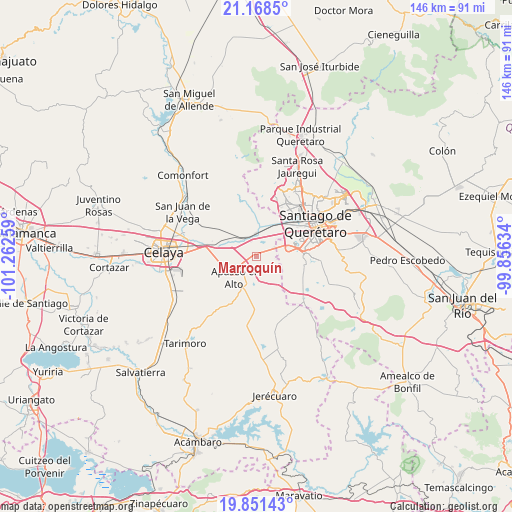
Marroquín GPS coordinates[2]
20° 30' 40.968" North, 100° 33' 34.056" West
| Map corner | latitude | longitude |
|---|---|---|
| Upper-left | 21.1685°, | -101.26259° |
| Center: | 20.51138°, | -100.55946° |
| Lower-right: | 19.85143°, | -99.85634° |
| Map W x H: | 146.4×146.4 km | = 91×91mi |
| max Lat: | 32.7° ⇑32% North |
| Marroquín: | 20.51138° |
| min Lat: | ⇓68% South 14.53588° |
| min Long | Marroquín | max Long |
| -117.105° | -100.55946° | -86.73105° |
| W 30%⇐ | ⇒70% E |
Elevation
Elevation of Marroquín is 1857 m = 6093 ft, and this is 603.3 m = 1979 ft above average elevation for this country.
| Max E: |
3497 m = 11473 ft | 33.7% |
| Marroquín | 1857 m 6093 ft | |
| Avg. | 1253.7 m = 4113 ft | |
Min E: |
-1 m = -3 ft | 66.3% |
See also: Mexico elevation on elevation.city.
Geographical zone
Marroquín is located in North Torrid zone (between Equator and Tropic of Cancer). Distance of this Northern Tropic circle is 325.3 km =202.1 mi to North.| Distance of | km | miles | from Marroquín |
|---|---|---|---|
| North Pole | 7726.4 | 4801 | to North |
| Arctic Circle | 5120.5 | 3181.7 | to North |
| Tropic Cancer | 325.3 | 202.1 | to North |
| Equator | 2280.7 | 1417.2 | to South |


Nearby cities:
15 places around Marroquín: (largest is in red/bold)
• Ameche
5.2 km =3.2 mi,  331°
331°
• Caleras de Ameche
5.6 km =3.5 mi,  359°
359°
• Caleras de Obrajuelo
6.4 km =4 mi,  2°
2°
• Coachiti
6.2 km =3.9 mi, 329°
• El Nacimiento
5.9 km =3.7 mi,  297°
297°
• El Romeral
7.3 km =4.5 mi,  66°
66°
• El Sabino
4.2 km =2.6 mi,  229°
229°
• La Norita
6.5 km =4 mi,  43°
43°
• Ojo de Agua de Espejo
6 km =3.7 mi,  162°
162°
• San Antonio Calichar
4.6 km =2.9 mi,  110°
110°
• San Bartolomé Aguas Calientes
2.1 km =1.3 mi,  146°
146°
• San Cristóbal
5.9 km =3.7 mi,  261°
261°
• San Juan del Llanito
2.1 km =1.3 mi,  82°
82°
• San Pedro Tenango
7.6 km =4.7 mi,  266°
266°
• San Vicente
5.1 km =3.2 mi, 161°
Sources, notices
• [Note1] Compared only with cities in Mexico existing in our database
• [Src1] Map data: © OpenStreetMap contributors (CC-BY-SA)
• [Src2] Other city data from geonames.org with taken over terms of usage.
• [Src3] Geographical zone / Annual Mean Temperature by Robert A. Rohde @ Wikipedia
