San Pedro Tenango geodata
San Pedro Tenango (Guanajuato) is a populated place; located in Mexico in America/Mexico_City (GMT-6) time zone. With population of 3,674 people, there are 2499 cities with bigger population in this country. Compared to other cities in Mexico, 68% of cities are located further ↓South; 70.6% of cities are located further →East and 63.5% of cities have lower elevation than San Pedro Tenango. Note1


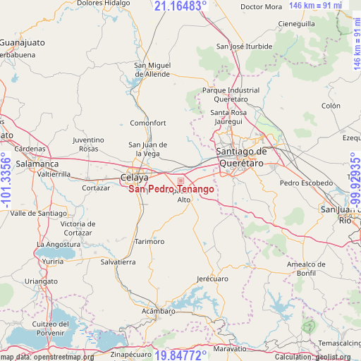
San Pedro Tenango GPS coordinates[2]
20° 30' 27.684" North, 100° 37' 56.892" West
| Map corner | latitude | longitude |
|---|---|---|
| Upper-left | 21.16483°, | -101.3356° |
| Center: | 20.50769°, | -100.63247° |
| Lower-right: | 19.84772°, | -99.92935° |
| Map W x H: | 146.4×146.5 km | = 91×91mi |
| max Lat: | 32.7° ⇑32% North |
| San Pedro Tenango: | 20.50769° |
| min Lat: | ⇓68% South 14.53588° |
| min Long | San Pedro Tenan | max Long |
| -117.105° | -100.63247° | -86.73105° |
| W 29.4%⇐ | ⇒70.6% E |
Elevation
Elevation of San Pedro Tenango is 1789 m = 5869 ft, and this is 535.3 m = 1756 ft above average elevation for this country.
| Max E: |
3497 m = 11473 ft | 36.5% |
| San Pedro Tenango | 1789 m 5869 ft | |
| Avg. | 1253.7 m = 4113 ft | |
Min E: |
-1 m = -3 ft | 63.5% |
See also: Mexico elevation on elevation.city.
Geographical zone
San Pedro Tenango is located in North Torrid zone (between Equator and Tropic of Cancer). Distance of this Northern Tropic circle is 325.7 km =202.4 mi to North.| Distance of | km | miles | from San Pedro Tenango |
|---|---|---|---|
| North Pole | 7726.8 | 4801.2 | to North |
| Arctic Circle | 5120.9 | 3182 | to North |
| Tropic Cancer | 325.7 | 202.4 | to North |
| Equator | 2280.2 | 1416.9 | to South |


Nearby cities:
15 places around San Pedro Tenango: (largest is in red/bold)
• Ameche
7.1 km =4.4 mi,  45°
45°
• Apaseo el Alto
5.7 km =3.5 mi,  167°
167°
• Apaseo el Grande
6.8 km =4.2 mi,  307°
307°
• Coachiti
7.3 km =4.5 mi,  37°
37°
• El Nacimiento
3.9 km =2.4 mi, 36°
• El Sabino
5 km =3.1 mi,  117°
117°
• El Tunal
7 km =4.3 mi,  10°
10°
• Guadalupe del Monte
5.5 km =3.4 mi,  351°
351°
• La Palma
6.9 km =4.3 mi,  277°
277°
• La Purísima
4.2 km =2.6 mi, 280°
• Marroquín
7.6 km =4.7 mi,  86°
86°
• San Cristóbal
1.8 km =1.1 mi,  103°
103°
• San José Viborillas
6.7 km =4.2 mi,  358°
358°
• San José de Agua Azul
3.4 km =2.1 mi,  226°
226°
• Tenango el Nuevo
4.8 km =3 mi,  302°
302°
Sources, notices
• [Note1] Compared only with cities in Mexico existing in our database
• [Src1] Map data: © OpenStreetMap contributors (CC-BY-SA)
• [Src2] Other city data from geonames.org with taken over terms of usage.
• [Src3] Geographical zone / Annual Mean Temperature by Robert A. Rohde @ Wikipedia
