Marín geodata
Marín (Nuevo León) is a seat of a second-order administrative division; located in Mexico in America/Monterrey (GMT-6) time zone. With population of 3,075 people, there are 2933 cities with bigger population in this country. Compared to other cities in Mexico, 94.8% of cities are located further ↓South; 64.4% of cities are located further →East and 70.2% of cities have higher elevation than Marín. Note1


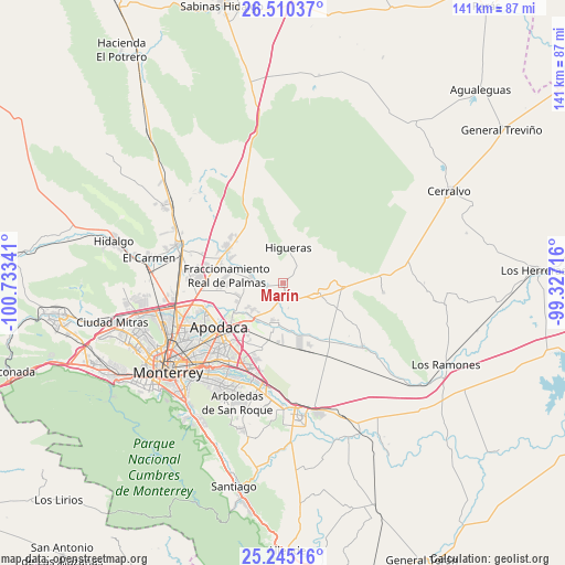
Marín GPS coordinates[2]
25° 52' 46.056" North, 100° 1' 49.008" West
| Map corner | latitude | longitude |
|---|---|---|
| Upper-left | 26.51037°, | -100.73341° |
| Center: | 25.87946°, | -100.03028° |
| Lower-right: | 25.24516°, | -99.32716° |
| Map W x H: | 140.7×140.7 km | = 87.4×87.4mi |
| max Lat: | 32.7° ⇑5.2% North |
| Marín: | 25.87946° |
| min Lat: | ⇓94.8% South 14.53588° |
| min Long | Marín | max Long |
| -117.105° | -100.03028° | -86.73105° |
| W 35.6%⇐ | ⇒64.4% E |
Elevation
Elevation of Marín is 406 m = 1332 ft, and this is 847.7 m = 2781 ft below average elevation for this country.
| Max E: |
3497 m = 11473 ft | 70.2% |
| Avg. | 1253.7 m = 4113 ft | |
| Marín | 406 m = 1332 ft | |
Min E: |
-1 m = -3 ft | 29.8% |
See also: Mexico elevation on elevation.city.
Geographical zone
Marín is located in North temperate zone (between Tropic of Cancer and the Arctic Circle). Distance of this Northern Tropic circle is 271.6 km =168.8 mi to South.| Distance of | km | miles | from Marín |
|---|---|---|---|
| North Pole | 7129.5 | 4430.1 | to North |
| Arctic Circle | 4523.6 | 2810.8 | to North |
| Tropic Cancer | 271.6 | 168.8 | to South |
| Equator | 2877.5 | 1788 | to South |


Nearby cities:
15 places around Marín: (largest is in red/bold)
• Agua Fría
13.9 km =8.6 mi,  237°
237°
• Artemio Treviño
12.3 km =7.6 mi,  246°
246°
• Ciénega de Flores
16 km =9.9 mi,  301°
301°
• Colinas del Aeropuerto
10 km =6.2 mi,  226°
226°
• Doctor González
8.9 km =5.5 mi,  104°
104°
• Fraccionamiento Real Palmas
13.2 km =8.2 mi,  281°
281°
• General Zuazua
8 km =5 mi, 282°
• Hacienda San Pedro
13.8 km =8.6 mi,  286°
286°
• Higueras
9.1 km =5.7 mi,  9°
9°
• Ladrillera (Entronque Pesquería)
11.1 km =6.9 mi,  219°
219°
• Pesquería
10.7 km =6.6 mi,  191°
191°
• Portal de las Salinas
16.1 km =10 mi,  315°
315°
• Real del Sol
16.4 km =10.2 mi, 293°
• Villas de Alcalá
16 km =9.9 mi, 284°
• Zacatecas
11.3 km =7 mi, 228°
Sources, notices
• [Note1] Compared only with cities in Mexico existing in our database
• [Src1] Map data: © OpenStreetMap contributors (CC-BY-SA)
• [Src2] Other city data from geonames.org with taken over terms of usage.
• [Src3] Geographical zone / Annual Mean Temperature by Robert A. Rohde @ Wikipedia
