Jesús Gómez Portugal geodata
Jesús Gómez Portugal (Aguascalientes) is a populated place; located in Mexico in America/Mexico_City (GMT-6) time zone. With population of 8,579 people, there are 1112 cities with bigger population in this country. Compared to other cities in Mexico, 84.2% of cities are located further ↓South; 82.8% of cities are located further →East and 67.6% of cities have lower elevation than Jesús Gómez Portugal. Note1


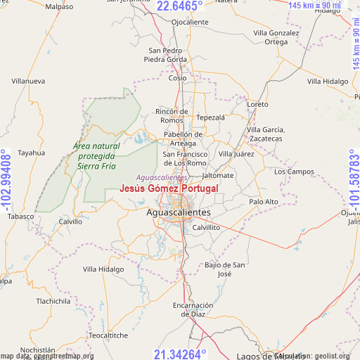
Jesús Gómez Portugal GPS coordinates[2]
21° 59' 45.852" North, 102° 17' 27.42" West
| Map corner | latitude | longitude |
|---|---|---|
| Upper-left | 22.6465°, | -102.99408° |
| Center: | 21.99607°, | -102.29095° |
| Lower-right: | 21.34264°, | -101.58783° |
| Map W x H: | 145×145 km | = 90.1×90.1mi |
| max Lat: | 32.7° ⇑15.8% North |
| Jesús Gómez Portugal: | 21.99607° |
| min Lat: | ⇓84.2% South 14.53588° |
| min Long | Jesús Gómez P | max Long |
| -117.105° | -102.29095° | -86.73105° |
| W 17.2%⇐ | ⇒82.8% E |
Elevation
Elevation of Jesús Gómez Portugal is 1880 m = 6168 ft, and this is 626.3 m = 2055 ft above average elevation for this country.
| Max E: |
3497 m = 11473 ft | 32.4% |
| Jesús Gómez Portugal | 1880 m 6168 ft | |
| Avg. | 1253.7 m = 4113 ft | |
Min E: |
-1 m = -3 ft | 67.6% |
See also: Mexico elevation on elevation.city.
Geographical zone
Jesús Gómez Portugal is located in North Torrid zone (between Equator and Tropic of Cancer). Distance of this Northern Tropic circle is 160.2 km =99.5 mi to North.| Distance of | km | miles | from Jesús Gómez Portugal |
|---|---|---|---|
| North Pole | 7561.3 | 4698.4 | to North |
| Arctic Circle | 4955.4 | 3079.1 | to North |
| Tropic Cancer | 160.2 | 99.5 | to North |
| Equator | 2445.7 | 1519.7 | to South |


Nearby cities:
15 places around Jesús Gómez Portugal: (largest is in red/bold)
• Arboledas Paso Blanco [Fraccionamiento]
3.8 km =2.4 mi,  197°
197°
• Chicalote
4.3 km =2.7 mi,  66°
66°
• Ejido la Guayana (Rancho Seco)
2.5 km =1.6 mi,  133°
133°
• Ex-Viñedos Guadalupe
4.4 km =2.7 mi,  156°
156°
• Jesús Gómez Portugal (Margaritas)
0.3 km =0.2 mi,  352°
352°
• La Florida
2 km =1.2 mi,  223°
223°
• Las Jaulas
2.8 km =1.7 mi,  325°
325°
• Macario J. Gómez [Colonia]
4.4 km =2.7 mi,  112°
112°
• Miravalle
3.4 km =2.1 mi, 218°
• Paseos de la Providencia [Fraccionamiento]
3.4 km =2.1 mi,  24°
24°
• Paso Blanco
3.7 km =2.3 mi,  227°
227°
• San Antonio de los Horcones
3.7 km =2.3 mi,  273°
273°
• Valladolid
3.7 km =2.3 mi,  318°
318°
• Valle de Aguascalientes
3.7 km =2.3 mi, 132°
• Viñedos Rivier
2.1 km =1.3 mi,  165°
165°
Sources, notices
• [Note1] Compared only with cities in Mexico existing in our database
• [Src1] Map data: © OpenStreetMap contributors (CC-BY-SA)
• [Src2] Other city data from geonames.org with taken over terms of usage.
• [Src3] Geographical zone / Annual Mean Temperature by Robert A. Rohde @ Wikipedia
