Ex-Viñedos Guadalupe geodata
Ex-Viñedos Guadalupe (Aguascalientes) is a populated place; located in Mexico in America/Mexico_City (GMT-6) time zone. With population of 3,499 people, there are 2612 cities with bigger population in this country. Compared to other cities in Mexico, 83.9% of cities are located further ↓South; 82.6% of cities are located further →East and 69.6% of cities have lower elevation than Ex-Viñedos Guadalupe. Note1


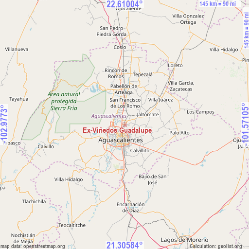
Ex-Viñedos Guadalupe GPS coordinates[2]
21° 57' 33.984" North, 102° 16' 27.012" West
| Map corner | latitude | longitude |
|---|---|---|
| Upper-left | 22.61004°, | -102.9773° |
| Center: | 21.95944°, | -102.27417° |
| Lower-right: | 21.30584°, | -101.57105° |
| Map W x H: | 145×145 km | = 90.1×90.1mi |
| max Lat: | 32.7° ⇑16.1% North |
| Ex-Viñedos Guadalupe: | 21.95944° |
| min Lat: | ⇓83.9% South 14.53588° |
| min Long | Ex-Viñedos Gua | max Long |
| -117.105° | -102.27417° | -86.73105° |
| W 17.4%⇐ | ⇒82.6% E |
Elevation
Elevation of Ex-Viñedos Guadalupe is 1917 m = 6289 ft, and this is 663.3 m = 2176 ft above average elevation for this country.
| Max E: |
3497 m = 11473 ft | 30.4% |
| Ex-Viñedos Guadalupe | 1917 m 6289 ft | |
| Avg. | 1253.7 m = 4113 ft | |
Min E: |
-1 m = -3 ft | 69.6% |
See also: Mexico elevation on elevation.city.
Geographical zone
Ex-Viñedos Guadalupe is located in North Torrid zone (between Equator and Tropic of Cancer). Distance of this Northern Tropic circle is 164.3 km =102.1 mi to North.| Distance of | km | miles | from Ex-Viñedos Guadalupe |
|---|---|---|---|
| North Pole | 7565.4 | 4700.9 | to North |
| Arctic Circle | 4959.5 | 3081.7 | to North |
| Tropic Cancer | 164.3 | 102.1 | to North |
| Equator | 2441.7 | 1517.2 | to South |


Nearby cities:
15 places around Ex-Viñedos Guadalupe: (largest is in red/bold)
• Arboledas Paso Blanco [Fraccionamiento]
2.9 km =1.8 mi,  279°
279°
• Cartagena [Fraccionamiento]
0.4 km =0.2 mi,  214°
214°
• Ejido la Guayana (Rancho Seco)
2.3 km =1.4 mi,  2°
2°
• Jesús Gómez Portugal
4.4 km =2.7 mi,  336°
336°
• Jesús Gómez Portugal (Margaritas)
4.8 km =3 mi, 338°
• La Florida
4.1 km =2.5 mi,  310°
310°
• Los Arenales
4.9 km =3 mi, 275°
• Macario J. Gómez [Colonia]
3.3 km =2.1 mi,  45°
45°
• Miravalle
4.1 km =2.5 mi,  290°
290°
• Montebello Della Stanza [Fraccionamiento]
2.6 km =1.6 mi,  176°
176°
• Paso Blanco
4.7 km =2.9 mi, 289°
• Puertecito de la Virgen
0.6 km =0.4 mi,  80°
80°
• Tepetates
4.9 km =3 mi,  266°
266°
• Valle de Aguascalientes
1.9 km =1.2 mi,  31°
31°
• Viñedos Rivier
2.4 km =1.5 mi,  329°
329°
Sources, notices
• [Note1] Compared only with cities in Mexico existing in our database
• [Src1] Map data: © OpenStreetMap contributors (CC-BY-SA)
• [Src2] Other city data from geonames.org with taken over terms of usage.
• [Src3] Geographical zone / Annual Mean Temperature by Robert A. Rohde @ Wikipedia
