El Maluco geodata
El Maluco (Michoacán) is a populated place; located in Mexico in America/Mexico_City (GMT-6) time zone. With population of 1,892 people, there are 4600 cities with bigger population in this country. Compared to other cities in Mexico, 60.1% of cities are located further ↓South; 78.8% of cities are located further →East and 58.5% of cities have lower elevation than El Maluco. Note1


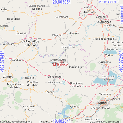
El Maluco GPS coordinates[2]
20° 8' 39.624" North, 101° 40' 31.008" West
| Map corner | latitude | longitude |
|---|---|---|
| Upper-left | 20.80305°, | -102.37841° |
| Center: | 20.14434°, | -101.67528° |
| Lower-right: | 19.48284°, | -100.97216° |
| Map W x H: | 146.8×146.8 km | = 91.2×91.2mi |
| max Lat: | 32.7° ⇑39.9% North |
| El Maluco: | 20.14434° |
| min Lat: | ⇓60.1% South 14.53588° |
| min Long | El Maluco | max Long |
| -117.105° | -101.67528° | -86.73105° |
| W 21.2%⇐ | ⇒78.8% E |
Elevation
Elevation of El Maluco is 1698 m = 5571 ft, and this is 444.3 m = 1458 ft above average elevation for this country.
| Max E: |
3497 m = 11473 ft | 41.5% |
| El Maluco | 1698 m 5571 ft | |
| Avg. | 1253.7 m = 4113 ft | |
Min E: |
-1 m = -3 ft | 58.5% |
See also: Mexico elevation on elevation.city.
Geographical zone
El Maluco is located in North Torrid zone (between Equator and Tropic of Cancer). Distance of this Northern Tropic circle is 366.1 km =227.5 mi to North.| Distance of | km | miles | from El Maluco |
|---|---|---|---|
| North Pole | 7767.2 | 4826.3 | to North |
| Arctic Circle | 5161.3 | 3207.1 | to North |
| Tropic Cancer | 366.1 | 227.5 | to North |
| Equator | 2239.8 | 1391.7 | to South |


Nearby cities:
15 places around El Maluco: (largest is in red/bold)
• Agua Caliente
10.8 km =6.7 mi,  215°
215°
• Angamacutiro de la Unión
3.8 km =2.4 mi,  279°
279°
• El Mármol
10 km =6.2 mi,  323°
323°
• Gildardo Magaña
10.4 km =6.5 mi,  15°
15°
• Héroes de la Revolución
5.1 km =3.2 mi, 321°
• Janamuato
10.6 km =6.6 mi,  117°
117°
• La Estancia del Río
9 km =5.6 mi,  203°
203°
• La Palma
8.9 km =5.5 mi,  229°
229°
• Miravalle
2.3 km =1.4 mi,  263°
263°
• Nuevo Progreso (Casas Viejas)
10.9 km =6.8 mi,  166°
166°
• Puerta de Agua Caliente
8.9 km =5.5 mi,  355°
355°
• San José del Maluco
1.2 km =0.7 mi, 280°
• San Martín
10.4 km =6.5 mi,  40°
40°
• Santiago Conguripo
5.7 km =3.5 mi,  326°
326°
• Villachuato
4.3 km =2.7 mi,  83°
83°
Sources, notices
• [Note1] Compared only with cities in Mexico existing in our database
• [Src1] Map data: © OpenStreetMap contributors (CC-BY-SA)
• [Src2] Other city data from geonames.org with taken over terms of usage.
• [Src3] Geographical zone / Annual Mean Temperature by Robert A. Rohde @ Wikipedia
