La Palma geodata
La Palma (Michoacán) is a populated place; located in Mexico in America/Mexico_City (GMT-6) time zone. With population of 505 people, there are 16660 cities with bigger population in this country. Compared to other cities in Mexico, 59% of cities are located further ↓South; 79.3% of cities are located further →East and 59.9% of cities have lower elevation than La Palma. Note1


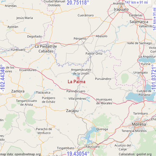
La Palma GPS coordinates[2]
20° 5' 32.1" North, 101° 44' 25.188" West
| Map corner | latitude | longitude |
|---|---|---|
| Upper-left | 20.75118°, | -102.44346° |
| Center: | 20.09225°, | -101.74033° |
| Lower-right: | 19.43054°, | -101.03721° |
| Map W x H: | 146.8×146.8 km | = 91.2×91.2mi |
| max Lat: | 32.7° ⇑41% North |
| La Palma: | 20.09225° |
| min Lat: | ⇓59% South 14.53588° |
| min Long | La Palma | max Long |
| -117.105° | -101.74033° | -86.73105° |
| W 20.7%⇐ | ⇒79.3% E |
Elevation
Elevation of La Palma is 1724 m = 5656 ft, and this is 470.3 m = 1543 ft above average elevation for this country.
| Max E: |
3497 m = 11473 ft | 40.1% |
| La Palma | 1724 m 5656 ft | |
| Avg. | 1253.7 m = 4113 ft | |
Min E: |
-1 m = -3 ft | 59.9% |
See also: Mexico elevation on elevation.city.
Geographical zone
La Palma is located in North Torrid zone (between Equator and Tropic of Cancer). Distance of this Northern Tropic circle is 371.9 km =231.1 mi to North.| Distance of | km | miles | from La Palma |
|---|---|---|---|
| North Pole | 7773 | 4829.9 | to North |
| Arctic Circle | 5167.1 | 3210.7 | to North |
| Tropic Cancer | 371.9 | 231.1 | to North |
| Equator | 2234 | 1388.1 | to South |


Nearby cities:
15 places around La Palma: (largest is in red/bold)
• Agua Caliente
3.1 km =1.9 mi,  168°
168°
• Angamacutiro de la Unión
7.1 km =4.4 mi,  25°
25°
• Curimeo
9.3 km =5.8 mi,  149°
149°
• El Maluco
8.9 km =5.5 mi,  49°
49°
• Héroes de la Revolución
10.5 km =6.5 mi,  20°
20°
• J. Trinidad Regalado (La Colonia)
7.1 km =4.4 mi,  187°
187°
• La Estancia del Río
4.1 km =2.5 mi,  127°
127°
• Miravalle
7.1 km =4.4 mi,  39°
39°
• Nuevo Progreso (Casas Viejas)
10.5 km =6.5 mi,  117°
117°
• Panindícuaro
12.1 km =7.5 mi, 190°
• San José del Maluco
8.2 km =5.1 mi, 43°
• San Miguel
11.5 km =7.1 mi, 120°
• San Miguel Epejan
8.4 km =5.2 mi,  249°
249°
• Santiago Conguripo
11.2 km =7 mi, 18°
• Villachuato
12.7 km =7.9 mi,  60°
60°
Sources, notices
• [Note1] Compared only with cities in Mexico existing in our database
• [Src1] Map data: © OpenStreetMap contributors (CC-BY-SA)
• [Src2] Other city data from geonames.org with taken over terms of usage.
• [Src3] Geographical zone / Annual Mean Temperature by Robert A. Rohde @ Wikipedia
