Madrid geodata
Madrid (Colima) is a populated place; located in Mexico in America/Mexico_City (GMT-6) time zone. With population of 3,790 people, there are 2412 cities with bigger population in this country. Compared to other cities in Mexico, 63.3% of cities are located further ↑North; 89.6% of cities are located further →East and 76.1% of cities have higher elevation than Madrid. Note1


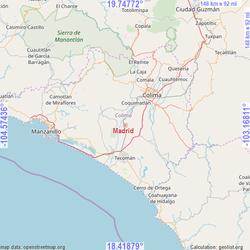
Madrid GPS coordinates[2]
19° 5' 4.524" North, 103° 52' 16.428" West
| Map corner | latitude | longitude |
|---|---|---|
| Upper-left | 19.74772°, | -104.57436° |
| Center: | 19.08459°, | -103.87123° |
| Lower-right: | 18.41879°, | -103.16811° |
| Map W x H: | 147.8×147.8 km | = 91.8×91.8mi |
| max Lat: | 32.7° ⇑63.3% North |
| Madrid: | 19.08459° |
| min Lat: | ⇓36.7% South 14.53588° |
| min Long | Madrid | max Long |
| -117.105° | -103.87123° | -86.73105° |
| W 10.4%⇐ | ⇒89.6% E |
Elevation
Elevation of Madrid is 183 m = 600 ft, and this is 1070.7 m = 3513 ft below average elevation for this country.
| Max E: |
3497 m = 11473 ft | 76.1% |
| Avg. | 1253.7 m = 4113 ft | |
| Madrid | 183 m = 600 ft | |
Min E: |
-1 m = -3 ft | 23.9% |
See also: Mexico elevation on elevation.city.
Geographical zone
Madrid is located in North Torrid zone (between Equator and Tropic of Cancer). Distance of this Northern Tropic circle is 483.9 km =300.7 mi to North.| Distance of | km | miles | from Madrid |
|---|---|---|---|
| North Pole | 7885.1 | 4899.6 | to North |
| Arctic Circle | 5279.2 | 3280.3 | to North |
| Tropic Cancer | 483.9 | 300.7 | to North |
| Equator | 2122 | 1318.5 | to South |


Nearby cities:
15 places around Madrid: (largest is in red/bold)
• Augusto Gómez Villanueva
15.4 km =9.6 mi,  242°
242°
• Caleras
9.8 km =6.1 mi,  184°
184°
• Ciudad de Armería
19 km =11.8 mi,  210°
210°
• Cofradía de Juárez
16.2 km =10.1 mi, 213°
• Colonia Ladislao Moreno
21 km =13 mi,  192°
192°
• Coquimatlán
15 km =9.3 mi,  25°
25°
• Ixtlahuacán
16.9 km =10.5 mi,  123°
123°
• La Esperanza
9.8 km =6.1 mi,  4°
4°
• Las Guásimas (Las Borregas)
15.8 km =9.8 mi,  77°
77°
• Los Asmoles
11.1 km =6.9 mi,  68°
68°
• Piscila
19.7 km =12.2 mi, 65°
• Pueblo Juárez (La Magdalena)
11.1 km =6.9 mi,  325°
325°
• Rincón de López
7.3 km =4.5 mi, 241°
• Tecolapa
8.4 km =5.2 mi,  149°
149°
• Tecomán
18.7 km =11.6 mi, 182°
Sources, notices
• [Note1] Compared only with cities in Mexico existing in our database
• [Src1] Map data: © OpenStreetMap contributors (CC-BY-SA)
• [Src2] Other city data from geonames.org with taken over terms of usage.
• [Src3] Geographical zone / Annual Mean Temperature by Robert A. Rohde @ Wikipedia
