Cofradía de Juárez geodata
Cofradía de Juárez (Colima) is a populated place; located in Mexico in America/Mexico_City (GMT-6) time zone. With population of 6,202 people, there are 1500 cities with bigger population in this country. Compared to other cities in Mexico, 65.5% of cities are located further ↑North; 89.8% of cities are located further →East and 84.1% of cities have higher elevation than Cofradía de Juárez. Note1


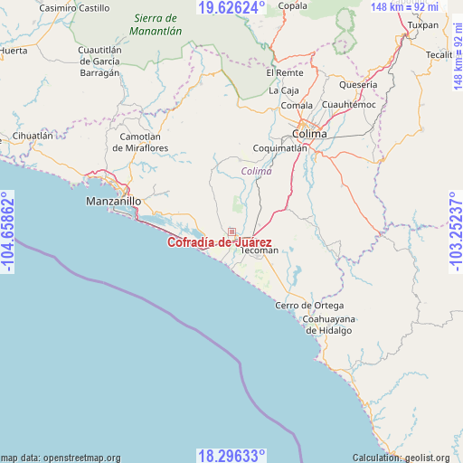
Cofradía de Juárez GPS coordinates[2]
18° 57' 45.396" North, 103° 57' 19.764" West
| Map corner | latitude | longitude |
|---|---|---|
| Upper-left | 19.62624°, | -104.65862° |
| Center: | 18.96261°, | -103.95549° |
| Lower-right: | 18.29633°, | -103.25237° |
| Map W x H: | 147.9×147.9 km | = 91.9×91.9mi |
| max Lat: | 32.7° ⇑65.5% North |
| Cofradía de Juárez: | 18.96261° |
| min Lat: | ⇓34.5% South 14.53588° |
| min Long | Cofradía de Ju | max Long |
| -117.105° | -103.95549° | -86.73105° |
| W 10.2%⇐ | ⇒89.8% E |
Elevation
Elevation of Cofradía de Juárez is 51 m = 167 ft, and this is 1202.7 m = 3946 ft below average elevation for this country.
| Max E: |
3497 m = 11473 ft | 84.1% |
| Avg. | 1253.7 m = 4113 ft | |
| Cofradía de Juárez | 51 m = 167 ft | |
Min E: |
-1 m = -3 ft | 15.9% |
See also: Mexico elevation on elevation.city.
Geographical zone
Cofradía de Juárez is located in North Torrid zone (between Equator and Tropic of Cancer). Distance of this Northern Tropic circle is 497.5 km =309.1 mi to North.| Distance of | km | miles | from Cofradía de Juárez |
|---|---|---|---|
| North Pole | 7898.6 | 4908 | to North |
| Arctic Circle | 5292.7 | 3288.7 | to North |
| Tropic Cancer | 497.5 | 309.1 | to North |
| Equator | 2108.4 | 1310.1 | to South |


Nearby cities:
15 places around Cofradía de Juárez: (largest is in red/bold)
• Augusto Gómez Villanueva
8.1 km =5 mi,  323°
323°
• Caleras
8.9 km =5.5 mi,  64°
64°
• Ciudad de Armería
2.9 km =1.8 mi,  198°
198°
• Cofradía de Morelos
16.3 km =10.1 mi,  130°
130°
• Colonia Ladislao Moreno
8.3 km =5.2 mi,  147°
147°
• Cuyutlán
12.8 km =8 mi,  248°
248°
• Los Reyes (Zorrillos)
11.5 km =7.1 mi,  280°
280°
• Madrid
16.2 km =10.1 mi,  33°
33°
• Nuevo Cuyutlán
18.2 km =11.3 mi,  290°
290°
• Rincón de López
10.3 km =6.4 mi,  13°
13°
• San Buenaventura
22.3 km =13.9 mi, 285°
• Santa Rita
15.5 km =9.6 mi, 290°
• Tecolapa
14.5 km =9 mi, 64°
• Tecomán
9.6 km =6 mi,  121°
121°
• Venustiano Carranza
17.2 km =10.7 mi, 288°
Sources, notices
• [Note1] Compared only with cities in Mexico existing in our database
• [Src1] Map data: © OpenStreetMap contributors (CC-BY-SA)
• [Src2] Other city data from geonames.org with taken over terms of usage.
• [Src3] Geographical zone / Annual Mean Temperature by Robert A. Rohde @ Wikipedia
