Coquimatlán geodata
Coquimatlán (Colima) is a seat of a second-order administrative division; located in Mexico in America/Mexico_City (GMT-6) time zone. With population of 13,358 people, there are 730 cities with bigger population in this country. Compared to other cities in Mexico, 61% of cities are located further ↑North; 89.4% of cities are located further →East and 71.6% of cities have higher elevation than Coquimatlán. Note1


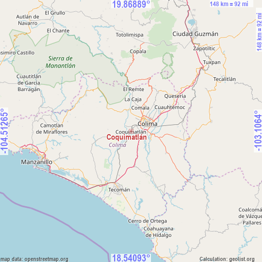
Coquimatlán GPS coordinates[2]
19° 12' 22.5" North, 103° 48' 34.272" West
| Map corner | latitude | longitude |
|---|---|---|
| Upper-left | 19.86889°, | -104.51265° |
| Center: | 19.20625°, | -103.80952° |
| Lower-right: | 18.54093°, | -103.1064° |
| Map W x H: | 147.7×147.7 km | = 91.8×91.8mi |
| max Lat: | 32.7° ⇑61% North |
| Coquimatlán: | 19.20625° |
| min Lat: | ⇓39% South 14.53588° |
| min Long | Coquimatlán | max Long |
| -117.105° | -103.80952° | -86.73105° |
| W 10.6%⇐ | ⇒89.4% E |
Elevation
Elevation of Coquimatlán is 344 m = 1129 ft, and this is 909.7 m = 2985 ft below average elevation for this country.
| Max E: |
3497 m = 11473 ft | 71.6% |
| Avg. | 1253.7 m = 4113 ft | |
| Coquimatlán | 344 m = 1129 ft | |
Min E: |
-1 m = -3 ft | 28.4% |
See also: Mexico elevation on elevation.city.
Geographical zone
Coquimatlán is located in North Torrid zone (between Equator and Tropic of Cancer). Distance of this Northern Tropic circle is 470.4 km =292.3 mi to North.| Distance of | km | miles | from Coquimatlán |
|---|---|---|---|
| North Pole | 7871.5 | 4891.1 | to North |
| Arctic Circle | 5265.6 | 3271.9 | to North |
| Tropic Cancer | 470.4 | 292.3 | to North |
| Equator | 2135.5 | 1326.9 | to South |


Nearby cities:
15 places around Coquimatlán: (largest is in red/bold)
• Ciudad de Villa de Álvarez
10.1 km =6.3 mi,  48°
48°
• Colima
9.9 km =6.2 mi,  60°
60°
• Comala
14.4 km =8.9 mi,  21°
21°
• El Chanal
14.7 km =9.1 mi, 47°
• El Trapiche
17.5 km =10.9 mi, 62°
• La Caja
18.3 km =11.4 mi,  3°
3°
• La Esperanza
6.8 km =4.2 mi,  236°
236°
• Las Guásimas (Las Borregas)
13.4 km =8.3 mi,  138°
138°
• Los Asmoles
10.3 km =6.4 mi,  157°
157°
• Madrid
15 km =9.3 mi,  205°
205°
• Piscila
12.5 km =7.8 mi,  114°
114°
• Pueblo Juárez (La Magdalena)
13.5 km =8.4 mi,  251°
251°
• Suchitlán
21.4 km =13.3 mi,  28°
28°
• Tecolapa
20.9 km =13 mi,  186°
186°
• Zacualpan
17.5 km =10.9 mi,  354°
354°
Sources, notices
• [Note1] Compared only with cities in Mexico existing in our database
• [Src1] Map data: © OpenStreetMap contributors (CC-BY-SA)
• [Src2] Other city data from geonames.org with taken over terms of usage.
• [Src3] Geographical zone / Annual Mean Temperature by Robert A. Rohde @ Wikipedia
