La Esperanza geodata
La Esperanza (Colima) is a populated place; located in Mexico in America/Mexico_City (GMT-6) time zone. With population of 640 people, there are 13529 cities with bigger population in this country. Compared to other cities in Mexico, 61.8% of cities are located further ↑North; 89.6% of cities are located further →East and 73.8% of cities have higher elevation than La Esperanza. Note1


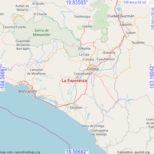
La Esperanza GPS coordinates[2]
19° 10' 20.172" North, 103° 51' 48.744" West
| Map corner | latitude | longitude |
|---|---|---|
| Upper-left | 19.83505°, | -104.56667° |
| Center: | 19.17227°, | -103.86354° |
| Lower-right: | 18.50682°, | -103.16042° |
| Map W x H: | 147.7×147.7 km | = 91.8×91.8mi |
| max Lat: | 32.7° ⇑61.8% North |
| La Esperanza: | 19.17227° |
| min Lat: | ⇓38.2% South 14.53588° |
| min Long | La Esperanza | max Long |
| -117.105° | -103.86354° | -86.73105° |
| W 10.4%⇐ | ⇒89.6% E |
Elevation
Elevation of La Esperanza is 264 m = 866 ft, and this is 989.7 m = 3247 ft below average elevation for this country.
| Max E: |
3497 m = 11473 ft | 73.8% |
| Avg. | 1253.7 m = 4113 ft | |
| La Esperanza | 264 m = 866 ft | |
Min E: |
-1 m = -3 ft | 26.2% |
See also: Mexico elevation on elevation.city.
Geographical zone
La Esperanza is located in North Torrid zone (between Equator and Tropic of Cancer). Distance of this Northern Tropic circle is 474.2 km =294.7 mi to North.| Distance of | km | miles | from La Esperanza |
|---|---|---|---|
| North Pole | 7875.3 | 4893.5 | to North |
| Arctic Circle | 5269.4 | 3274.3 | to North |
| Tropic Cancer | 474.2 | 294.7 | to North |
| Equator | 2131.8 | 1324.6 | to South |


Nearby cities:
15 places around La Esperanza: (largest is in red/bold)
• Augusto Gómez Villanueva
22.2 km =13.8 mi,  220°
220°
• Caleras
19.6 km =12.2 mi,  184°
184°
• Ciudad de Villa de Álvarez
16.9 km =10.5 mi,  51°
51°
• Colima
16.7 km =10.4 mi,  58°
58°
• Comala
20.4 km =12.7 mi,  32°
32°
• Coquimatlán
6.8 km =4.2 mi, 56°
• El Chanal
21.4 km =13.3 mi, 50°
• Las Guásimas (Las Borregas)
15.8 km =9.8 mi,  113°
113°
• Los Asmoles
11.1 km =6.9 mi,  121°
121°
• Madrid
9.8 km =6.1 mi, 184°
• Piscila
17.1 km =10.6 mi,  94°
94°
• Pueblo Juárez (La Magdalena)
7.1 km =4.4 mi,  265°
265°
• Rincón de López
15.1 km =9.4 mi,  208°
208°
• Tecolapa
17.4 km =10.8 mi,  168°
168°
• Zacualpan
21.6 km =13.4 mi,  10°
10°
Sources, notices
• [Note1] Compared only with cities in Mexico existing in our database
• [Src1] Map data: © OpenStreetMap contributors (CC-BY-SA)
• [Src2] Other city data from geonames.org with taken over terms of usage.
• [Src3] Geographical zone / Annual Mean Temperature by Robert A. Rohde @ Wikipedia
