La Sábila geodata
La Sábila (Sonora) is a populated place; located in Mexico in America/Hermosillo (GMT-7) time zone. With population of 909 people, there are 9599 cities with bigger population in this country. Compared to other cities in Mexico, 96% of cities are located further ↓South; 97.6% of cities are located further →East and 99.3% of cities have higher elevation than La Sábila. Note1


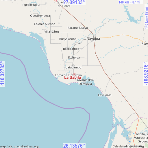
La Sábila GPS coordinates[2]
26° 45' 55.008" North, 109° 37' 28.992" West
| Map corner | latitude | longitude |
|---|---|---|
| Upper-left | 27.39133°, | -110.32785° |
| Center: | 26.76528°, | -109.62472° |
| Lower-right: | 26.13576°, | -108.9216° |
| Map W x H: | 139.6×139.6 km | = 86.7×86.7mi |
| max Lat: | 32.7° ⇑4% North |
| La Sábila: | 26.76528° |
| min Lat: | ⇓96% South 14.53588° |
| min Long | La Sábila | max Long |
| -117.105° | -109.62472° | -86.73105° |
| W 2.4%⇐ | ⇒97.6% E |
Elevation
Elevation of La Sábila is 5 m = 16 ft, and this is 1248.7 m = 4097 ft below average elevation for this country.
| Max E: |
3497 m = 11473 ft | 99.3% |
| Avg. | 1253.7 m = 4113 ft | |
| La Sábila | 5 m = 16 ft | |
Min E: |
-1 m = -3 ft | 0.7% |
See also: Mexico elevation on elevation.city.
Geographical zone
La Sábila is located in North temperate zone (between Tropic of Cancer and the Arctic Circle). Distance of this Northern Tropic circle is 370.1 km =230 mi to South.| Distance of | km | miles | from La Sábila |
|---|---|---|---|
| North Pole | 7031 | 4368.9 | to North |
| Arctic Circle | 4425.2 | 2749.7 | to North |
| Tropic Cancer | 370.1 | 230 | to South |
| Equator | 2976 | 1849.2 | to South |


Nearby cities:
15 places around La Sábila: (largest is in red/bold)
• 17 de Octubre
8.5 km =5.3 mi,  295°
295°
• Bachantahui
1.3 km =0.8 mi,  318°
318°
• El Riíto
1.7 km =1.1 mi,  340°
340°
• El Riíto de Mazaray
2.7 km =1.7 mi,  229°
229°
• Etchoropo
5.7 km =3.5 mi,  272°
272°
• Huatabampo
7 km =4.3 mi,  345°
345°
• Juraré
8.7 km =5.4 mi, 297°
• La Escalera
2.9 km =1.8 mi, 297°
• La Unión
6.3 km =3.9 mi,  15°
15°
• Las Parras
12.2 km =7.6 mi,  312°
312°
• Loma de Moroncarit
5.2 km =3.2 mi,  253°
253°
• Moroncarit
3.7 km =2.3 mi,  167°
167°
• Navobaxia
9 km =5.6 mi,  328°
328°
• San Antonio
2.5 km =1.6 mi,  103°
103°
• Yavaros
12.3 km =7.6 mi,  123°
123°
Sources, notices
• [Note1] Compared only with cities in Mexico existing in our database
• [Src1] Map data: © OpenStreetMap contributors (CC-BY-SA)
• [Src2] Other city data from geonames.org with taken over terms of usage.
• [Src3] Geographical zone / Annual Mean Temperature by Robert A. Rohde @ Wikipedia
