Navobaxia geodata
Navobaxia (Sonora) is a populated place; located in Mexico in America/Hermosillo (GMT-7) time zone. With population of 695 people, there are 12521 cities with bigger population in this country. Compared to other cities in Mexico, 96.1% of cities are located further ↓South; 97.8% of cities are located further →East and 99.1% of cities have higher elevation than Navobaxia. Note1


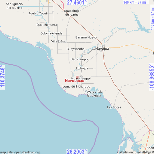
Navobaxia GPS coordinates[2]
26° 50' 3.984" North, 109° 40' 18.012" West
| Map corner | latitude | longitude |
|---|---|---|
| Upper-left | 27.4601°, | -110.3748° |
| Center: | 26.83444°, | -109.67167° |
| Lower-right: | 26.2053°, | -108.96855° |
| Map W x H: | 139.5×139.5 km | = 86.7×86.7mi |
| max Lat: | 32.7° ⇑3.9% North |
| Navobaxia: | 26.83444° |
| min Lat: | ⇓96.1% South 14.53588° |
| min Long | Navobaxia | max Long |
| -117.105° | -109.67167° | -86.73105° |
| W 2.2%⇐ | ⇒97.8% E |
Elevation
Elevation of Navobaxia is 6 m = 20 ft, and this is 1247.7 m = 4094 ft below average elevation for this country.
| Max E: |
3497 m = 11473 ft | 99.1% |
| Avg. | 1253.7 m = 4113 ft | |
| Navobaxia | 6 m = 20 ft | |
Min E: |
-1 m = -3 ft | 0.9% |
See also: Mexico elevation on elevation.city.
Geographical zone
Navobaxia is located in North temperate zone (between Tropic of Cancer and the Arctic Circle). Distance of this Northern Tropic circle is 377.8 km =234.8 mi to South.| Distance of | km | miles | from Navobaxia |
|---|---|---|---|
| North Pole | 7023.4 | 4364.1 | to North |
| Arctic Circle | 4417.5 | 2744.9 | to North |
| Tropic Cancer | 377.8 | 234.8 | to South |
| Equator | 2983.7 | 1854 | to South |


Nearby cities:
15 places around Navobaxia: (largest is in red/bold)
• 17 de Octubre
5.1 km =3.2 mi,  216°
216°
• Bachantahui
7.7 km =4.8 mi,  150°
150°
• El Caro
5.7 km =3.5 mi,  310°
310°
• El Riíto
7.3 km =4.5 mi, 146°
• Etchoropo
7.5 km =4.7 mi,  188°
188°
• Huatabampo
3.1 km =1.9 mi,  107°
107°
• Huitchaca
5.6 km =3.5 mi,  337°
337°
• Juraré
4.7 km =2.9 mi, 219°
• La Bocana
5.9 km =3.7 mi,  3°
3°
• La Escalera
6.7 km =4.2 mi,  161°
161°
• La Unión
6.5 km =4 mi,  104°
104°
• Las Guayabas
7.2 km =4.5 mi,  346°
346°
• Las Parras
4.5 km =2.8 mi,  276°
276°
• Pozo Dulce
8.2 km =5.1 mi, 278°
• Villa Tres Cruces
7.9 km =4.9 mi, 2°
Sources, notices
• [Note1] Compared only with cities in Mexico existing in our database
• [Src1] Map data: © OpenStreetMap contributors (CC-BY-SA)
• [Src2] Other city data from geonames.org with taken over terms of usage.
• [Src3] Geographical zone / Annual Mean Temperature by Robert A. Rohde @ Wikipedia
