Juraré geodata
Juraré (Sonora) is a populated place; located in Mexico in America/Hermosillo (GMT-7) time zone. With population of 1,451 people, there are 5948 cities with bigger population in this country. Compared to other cities in Mexico, 96% of cities are located further ↓South; 97.8% of cities are located further →East and 98.7% of cities have higher elevation than Juraré. Note1


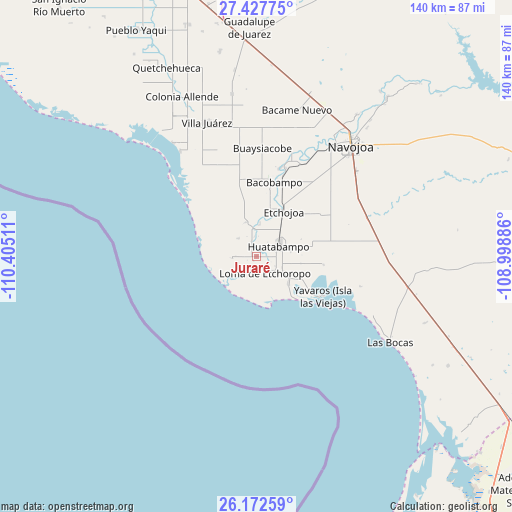
Juraré GPS coordinates[2]
26° 48' 6.876" North, 109° 42' 7.128" West
| Map corner | latitude | longitude |
|---|---|---|
| Upper-left | 27.42775°, | -110.40511° |
| Center: | 26.80191°, | -109.70198° |
| Lower-right: | 26.17259°, | -108.99886° |
| Map W x H: | 139.6×139.6 km | = 86.7×86.7mi |
| max Lat: | 32.7° ⇑4% North |
| Juraré: | 26.80191° |
| min Lat: | ⇓96% South 14.53588° |
| min Long | Juraré | max Long |
| -117.105° | -109.70198° | -86.73105° |
| W 2.2%⇐ | ⇒97.8% E |
Elevation
Elevation of Juraré is 7 m = 23 ft, and this is 1246.7 m = 4090 ft below average elevation for this country.
| Max E: |
3497 m = 11473 ft | 98.7% |
| Avg. | 1253.7 m = 4113 ft | |
| Juraré | 7 m = 23 ft | |
Min E: |
-1 m = -3 ft | 1.3% |
See also: Mexico elevation on elevation.city.
Geographical zone
Juraré is located in North temperate zone (between Tropic of Cancer and the Arctic Circle). Distance of this Northern Tropic circle is 374.2 km =232.5 mi to South.| Distance of | km | miles | from Juraré |
|---|---|---|---|
| North Pole | 7027 | 4366.4 | to North |
| Arctic Circle | 4421.1 | 2747.1 | to North |
| Tropic Cancer | 374.2 | 232.5 | to South |
| Equator | 2980.1 | 1851.7 | to South |


Nearby cities:
15 places around Juraré: (largest is in red/bold)
• 17 de Octubre
0.4 km =0.2 mi,  183°
183°
• Bachantahui
7.5 km =4.7 mi,  114°
114°
• El Caro
7.4 km =4.6 mi,  349°
349°
• El Riíto
7.5 km =4.7 mi, 109°
• El Riíto de Mazaray
8.1 km =5 mi,  136°
136°
• Etchoropo
4.3 km =2.7 mi,  153°
153°
• Huatabampo
6.5 km =4 mi,  65°
65°
• Huitchaca
8.8 km =5.5 mi,  5°
5°
• La Escalera
5.8 km =3.6 mi,  118°
118°
• La Sábila
8.7 km =5.4 mi, 117°
• Las Milpas
6.9 km =4.3 mi,  265°
265°
• Las Parras
4.4 km =2.7 mi,  341°
341°
• Loma de Moroncarit
6.2 km =3.9 mi, 153°
• Navobaxia
4.7 km =2.9 mi,  39°
39°
• Pozo Dulce
7 km =4.3 mi,  313°
313°
Sources, notices
• [Note1] Compared only with cities in Mexico existing in our database
• [Src1] Map data: © OpenStreetMap contributors (CC-BY-SA)
• [Src2] Other city data from geonames.org with taken over terms of usage.
• [Src3] Geographical zone / Annual Mean Temperature by Robert A. Rohde @ Wikipedia
