La Paz geodata
La Paz (Chihuahua) is a populated place; located in Mexico in America/Chihuahua (GMT-6) time zone. With population of 677 people, there are 12831 cities with bigger population in this country. Compared to other cities in Mexico, 97.5% of cities are located further ↓South; 94.1% of cities are located further →East and 56.5% of cities have lower elevation than La Paz. Note1


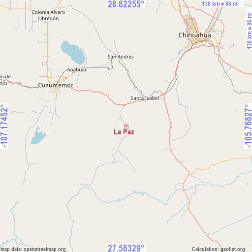
La Paz GPS coordinates[2]
28° 12' 16.992" North, 106° 28' 17.004" West
| Map corner | latitude | longitude |
|---|---|---|
| Upper-left | 28.82255°, | -107.17452° |
| Center: | 28.20472°, | -106.47139° |
| Lower-right: | 27.58329°, | -105.76827° |
| Map W x H: | 137.8×137.8 km | = 85.6×85.6mi |
| max Lat: | 32.7° ⇑2.5% North |
| La Paz: | 28.20472° |
| min Lat: | ⇓97.5% South 14.53588° |
| min Long | La Paz | max Long |
| -117.105° | -106.47139° | -86.73105° |
| W 5.9%⇐ | ⇒94.1% E |
Elevation
Elevation of La Paz is 1637 m = 5371 ft, and this is 383.3 m = 1258 ft above average elevation for this country.
| Max E: |
3497 m = 11473 ft | 43.5% |
| La Paz | 1637 m 5371 ft | |
| Avg. | 1253.7 m = 4113 ft | |
Min E: |
-1 m = -3 ft | 56.5% |
See also: Mexico elevation on elevation.city.
Geographical zone
La Paz is located in North temperate zone (between Tropic of Cancer and the Arctic Circle). Distance of this Northern Tropic circle is 530.2 km =329.5 mi to South.| Distance of | km | miles | from La Paz |
|---|---|---|---|
| North Pole | 6871 | 4269.4 | to North |
| Arctic Circle | 4265.1 | 2650.2 | to North |
| Tropic Cancer | 530.2 | 329.5 | to South |
| Equator | 3136.1 | 1948.7 | to South |


Nearby cities:
15 places around La Paz: (largest is in red/bold)
• Anáhuac
41.1 km =25.5 mi,  318°
318°
• Campo Número Dos
53.6 km =33.3 mi,  300°
300°
• Carichí
65.8 km =40.9 mi,  240°
240°
• Carretas
6.3 km =3.9 mi, 322°
• Chihuahua
60.8 km =37.8 mi,  38°
38°
• Cuauhtémoc
44.6 km =27.7 mi, 300°
• Cusihuiriachi
35.8 km =22.2 mi,  276°
276°
• Guadalupe Victoria (Santa Lucía)
37.7 km =23.4 mi, 303°
• San Andrés
38.2 km =23.7 mi,  355°
355°
• San Francisco de Borja
39.7 km =24.7 mi,  211°
211°
• San Lorenzo
5.7 km =3.5 mi,  185°
185°
• Santa Isabel
18.1 km =11.2 mi,  32°
32°
• Tutuaca
20.7 km =12.9 mi,  197°
197°
• Valentín Gómez Farías
11 km =6.8 mi, 276°
• Álamos de Cerro Prieto
62.1 km =38.6 mi,  268°
268°
Sources, notices
• [Note1] Compared only with cities in Mexico existing in our database
• [Src1] Map data: © OpenStreetMap contributors (CC-BY-SA)
• [Src2] Other city data from geonames.org with taken over terms of usage.
• [Src3] Geographical zone / Annual Mean Temperature by Robert A. Rohde @ Wikipedia
