Cuauhtémoc geodata
Cuauhtémoc (Chihuahua) is a seat of a second-order administrative division; located in Mexico in America/Chihuahua (GMT-6) time zone. With population of 114,007 people, there are 124 cities with bigger population in this country. Compared to other cities in Mexico, 97.7% of cities are located further ↓South; 94.3% of cities are located further →East and 76.2% of cities have lower elevation than Cuauhtémoc. Note1


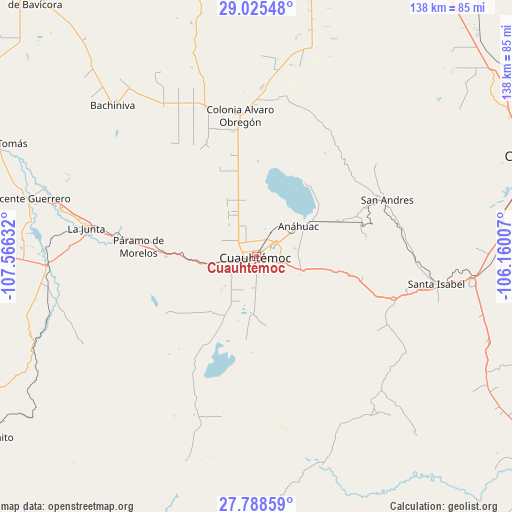
Cuauhtémoc GPS coordinates[2]
28° 24' 31.824" North, 106° 51' 47.484" West
| Map corner | latitude | longitude |
|---|---|---|
| Upper-left | 29.02548°, | -107.56632° |
| Center: | 28.40884°, | -106.86319° |
| Lower-right: | 27.78859°, | -106.16007° |
| Map W x H: | 137.5×137.5 km | = 85.4×85.4mi |
| max Lat: | 32.7° ⇑2.3% North |
| Cuauhtémoc: | 28.40884° |
| min Lat: | ⇓97.7% South 14.53588° |
| min Long | Cuauhtémoc | max Long |
| -117.105° | -106.86319° | -86.73105° |
| W 5.7%⇐ | ⇒94.3% E |
Elevation
Elevation of Cuauhtémoc is 2051 m = 6729 ft, and this is 797.3 m = 2616 ft above average elevation for this country.
| Max E: |
3497 m = 11473 ft | 23.8% |
| Cuauhtémoc | 2051 m 6729 ft | |
| Avg. | 1253.7 m = 4113 ft | |
Min E: |
-1 m = -3 ft | 76.2% |
See also: Cuauhtémoc elevation on elevation.city.
Geographical zone
Cuauhtémoc is located in North temperate zone (between Tropic of Cancer and the Arctic Circle). Distance of this Northern Tropic circle is 552.8 km =343.5 mi to South.| Distance of | km | miles | from Cuauhtémoc |
|---|---|---|---|
| North Pole | 6848.3 | 4255.3 | to North |
| Arctic Circle | 4242.4 | 2636.1 | to North |
| Tropic Cancer | 552.8 | 343.5 | to South |
| Equator | 3158.8 | 1962.8 | to South |


Nearby cities:
15 places around Cuauhtémoc: (largest is in red/bold)
• Adolfo López Mateos
43.2 km =26.8 mi,  278°
278°
• Anáhuac
14.1 km =8.8 mi,  53°
53°
• Campo Número Dos
9 km =5.6 mi,  298°
298°
• Carretas
38.8 km =24.1 mi,  117°
117°
• Colonia Margarita Maza de Juárez
38.8 km =24.1 mi,  355°
355°
• Cusihuiriachi
19 km =11.8 mi,  171°
171°
• Granjas el Venado
38.5 km =23.9 mi, 357°
• Guadalupe Victoria (Santa Lucía)
7.3 km =4.5 mi,  103°
103°
• La Paz
44.6 km =27.7 mi, 120°
• Paramo
31.7 km =19.7 mi,  274°
274°
• Pedernales
24.2 km =15 mi, 270°
• Ranchos de Santiago
31.9 km =19.8 mi,  258°
258°
• San Andrés
38.4 km =23.9 mi,  66°
66°
• Valentín Gómez Farías
34.7 km =21.6 mi,  127°
127°
• Álamos de Cerro Prieto
34.1 km =21.2 mi,  223°
223°
Sources, notices
• [Note1] Compared only with cities in Mexico existing in our database
• [Src1] Map data: © OpenStreetMap contributors (CC-BY-SA)
• [Src2] Other city data from geonames.org with taken over terms of usage.
• [Src3] Geographical zone / Annual Mean Temperature by Robert A. Rohde @ Wikipedia
