La Palma geodata
La Palma (Michoacán) is a populated place; located in Mexico in America/Mexico_City (GMT-6) time zone. With population of 3,787 people, there are 2416 cities with bigger population in this country. Compared to other cities in Mexico, 60.2% of cities are located further ↓South; 85% of cities are located further →East and 53.6% of cities have lower elevation than La Palma. Note1


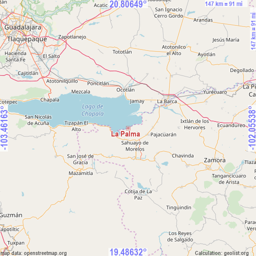
La Palma GPS coordinates[2]
20° 8' 52.08" North, 102° 45' 30.6" West
| Map corner | latitude | longitude |
|---|---|---|
| Upper-left | 20.80649°, | -103.46163° |
| Center: | 20.1478°, | -102.7585° |
| Lower-right: | 19.48632°, | -102.05538° |
| Map W x H: | 146.8×146.8 km | = 91.2×91.2mi |
| max Lat: | 32.7° ⇑39.8% North |
| La Palma: | 20.1478° |
| min Lat: | ⇓60.2% South 14.53588° |
| min Long | La Palma | max Long |
| -117.105° | -102.7585° | -86.73105° |
| W 15%⇐ | ⇒85% E |
Elevation
Elevation of La Palma is 1554 m = 5098 ft, and this is 300.3 m = 985 ft above average elevation for this country.
| Max E: |
3497 m = 11473 ft | 46.4% |
| La Palma | 1554 m 5098 ft | |
| Avg. | 1253.7 m = 4113 ft | |
Min E: |
-1 m = -3 ft | 53.6% |
See also: Mexico elevation on elevation.city.
Geographical zone
La Palma is located in North Torrid zone (between Equator and Tropic of Cancer). Distance of this Northern Tropic circle is 365.7 km =227.2 mi to North.| Distance of | km | miles | from La Palma |
|---|---|---|---|
| North Pole | 7766.8 | 4826.1 | to North |
| Arctic Circle | 5160.9 | 3206.8 | to North |
| Tropic Cancer | 365.7 | 227.2 | to North |
| Equator | 2240.2 | 1392 | to South |


Nearby cities:
15 places around La Palma: (largest is in red/bold)
• Cojumatlán de Régules
10.3 km =6.4 mi,  251°
251°
• Colonia Cuauhtémoc
15 km =9.3 mi,  165°
165°
• Colonia Niños Héroes
13.1 km =8.1 mi,  159°
159°
• Fraccionamiento 18 de Marzo
16.5 km =10.3 mi, 165°
• Fraccionamiento Colinas Universidad
14.6 km =9.1 mi, 171°
• Fraccionamiento San Miguel
11.4 km =7.1 mi,  138°
138°
• Francisco Sarabia (Cerrito Pelón)
14.3 km =8.9 mi, 155°
• Ibarra
16.8 km =10.4 mi,  57°
57°
• La Magdalena
11 km =6.8 mi,  66°
66°
• Morelos
14.2 km =8.8 mi,  89°
89°
• Ojo de Agua
5 km =3.1 mi,  180°
180°
• Pueblo Viejo
15.9 km =9.9 mi,  98°
98°
• Rincón de San Andrés
9.1 km =5.7 mi, 173°
• Sahuayo de Morelos
10.9 km =6.8 mi, 155°
• Venustiano Carranza
11.5 km =7.1 mi,  108°
108°
Sources, notices
• [Note1] Compared only with cities in Mexico existing in our database
• [Src1] Map data: © OpenStreetMap contributors (CC-BY-SA)
• [Src2] Other city data from geonames.org with taken over terms of usage.
• [Src3] Geographical zone / Annual Mean Temperature by Robert A. Rohde @ Wikipedia
