Pueblo Viejo geodata
Pueblo Viejo (Michoacán) is a populated place; located in Mexico in America/Mexico_City (GMT-6) time zone. With population of 842 people, there are 10390 cities with bigger population in this country. Compared to other cities in Mexico, 59.7% of cities are located further ↓South; 84.5% of cities are located further →East and 52.6% of cities have lower elevation than Pueblo Viejo. Note1


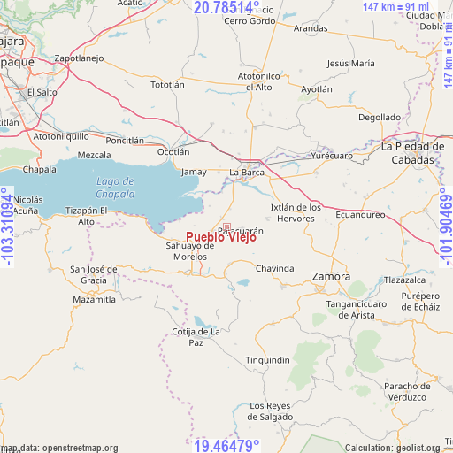
Pueblo Viejo GPS coordinates[2]
20° 7' 34.896" North, 102° 36' 28.116" West
| Map corner | latitude | longitude |
|---|---|---|
| Upper-left | 20.78514°, | -103.31094° |
| Center: | 20.12636°, | -102.60781° |
| Lower-right: | 19.46479°, | -101.90469° |
| Map W x H: | 146.8×146.8 km | = 91.2×91.2mi |
| max Lat: | 32.7° ⇑40.3% North |
| Pueblo Viejo: | 20.12636° |
| min Lat: | ⇓59.7% South 14.53588° |
| min Long | Pueblo Viejo | max Long |
| -117.105° | -102.60781° | -86.73105° |
| W 15.5%⇐ | ⇒84.5% E |
Elevation
Elevation of Pueblo Viejo is 1534 m = 5033 ft, and this is 280.3 m = 920 ft above average elevation for this country.
| Max E: |
3497 m = 11473 ft | 47.4% |
| Pueblo Viejo | 1534 m 5033 ft | |
| Avg. | 1253.7 m = 4113 ft | |
Min E: |
-1 m = -3 ft | 52.6% |
See also: Mexico elevation on elevation.city.
Geographical zone
Pueblo Viejo is located in North Torrid zone (between Equator and Tropic of Cancer). Distance of this Northern Tropic circle is 368.1 km =228.7 mi to North.| Distance of | km | miles | from Pueblo Viejo |
|---|---|---|---|
| North Pole | 7769.2 | 4827.6 | to North |
| Arctic Circle | 5163.3 | 3208.3 | to North |
| Tropic Cancer | 368.1 | 228.7 | to North |
| Equator | 2237.8 | 1390.5 | to South |


Nearby cities:
15 places around Pueblo Viejo: (largest is in red/bold)
• Cerrito de Cotijarán
13.3 km =8.3 mi,  195°
195°
• El Fortín
6 km =3.7 mi,  7°
7°
• El Paracho
9.1 km =5.7 mi,  102°
102°
• El Platanal
7.8 km =4.8 mi,  156°
156°
• Fraccionamiento San Miguel
10.3 km =6.4 mi,  233°
233°
• Ibarra
11.6 km =7.2 mi,  351°
351°
• La Luz
13.1 km =8.1 mi,  77°
77°
• La Magdalena
8.9 km =5.5 mi,  320°
320°
• Las Zarquillas
12.5 km =7.8 mi,  136°
136°
• Morelos
3 km =1.9 mi,  329°
329°
• Pajacuarán
4.4 km =2.7 mi, 100°
• San Gregorio
9.8 km =6.1 mi,  38°
38°
• Tecomatán
11.7 km =7.3 mi, 96°
• Venustiano Carranza
5 km =3.1 mi,  255°
255°
• Villamar
11.8 km =7.3 mi,  174°
174°
Sources, notices
• [Note1] Compared only with cities in Mexico existing in our database
• [Src1] Map data: © OpenStreetMap contributors (CC-BY-SA)
• [Src2] Other city data from geonames.org with taken over terms of usage.
• [Src3] Geographical zone / Annual Mean Temperature by Robert A. Rohde @ Wikipedia
