Venustiano Carranza geodata
Venustiano Carranza (Michoacán) is a seat of a second-order administrative division; located in Mexico in America/Mexico_City (GMT-6) time zone. With population of 11,987 people, there are 804 cities with bigger population in this country. Compared to other cities in Mexico, 59.5% of cities are located further ↓South; 84.6% of cities are located further →East and 52.4% of cities have lower elevation than Venustiano Carranza. Note1


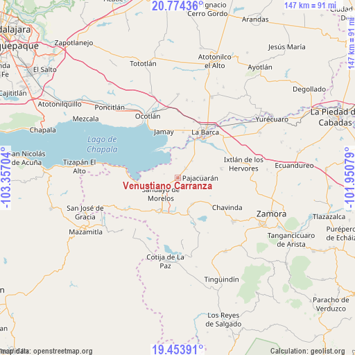
Venustiano Carranza GPS coordinates[2]
20° 6' 55.908" North, 102° 39' 14.076" West
| Map corner | latitude | longitude |
|---|---|---|
| Upper-left | 20.77436°, | -103.35704° |
| Center: | 20.11553°, | -102.65391° |
| Lower-right: | 19.45391°, | -101.95079° |
| Map W x H: | 146.8×146.8 km | = 91.2×91.2mi |
| max Lat: | 32.7° ⇑40.5% North |
| Venustiano Carranza: | 20.11553° |
| min Lat: | ⇓59.5% South 14.53588° |
| min Long | Venustiano Carr | max Long |
| -117.105° | -102.65391° | -86.73105° |
| W 15.4%⇐ | ⇒84.6% E |
Elevation
Elevation of Venustiano Carranza is 1531 m = 5023 ft, and this is 277.3 m = 910 ft above average elevation for this country.
| Max E: |
3497 m = 11473 ft | 47.6% |
| Venustiano Carranza | 1531 m 5023 ft | |
| Avg. | 1253.7 m = 4113 ft | |
Min E: |
-1 m = -3 ft | 52.4% |
See also: Mexico elevation on elevation.city.
Geographical zone
Venustiano Carranza is located in North Torrid zone (between Equator and Tropic of Cancer). Distance of this Northern Tropic circle is 369.3 km =229.5 mi to North.| Distance of | km | miles | from Venustiano Carranza |
|---|---|---|---|
| North Pole | 7770.4 | 4828.3 | to North |
| Arctic Circle | 5164.5 | 3209.1 | to North |
| Tropic Cancer | 369.3 | 229.5 | to North |
| Equator | 2236.6 | 1389.8 | to South |


Nearby cities:
15 places around Venustiano Carranza: (largest is in red/bold)
• Cerrito de Cotijarán
11.6 km =7.2 mi,  174°
174°
• Colonia Niños Héroes
10.7 km =6.6 mi,  215°
215°
• El Fortín
9.1 km =5.7 mi,  37°
37°
• El Platanal
9.9 km =6.2 mi,  126°
126°
• Fraccionamiento San Miguel
6 km =3.7 mi,  214°
214°
• Francisco Sarabia (Cerrito Pelón)
10.6 km =6.6 mi, 207°
• La Magdalena
8.1 km =5 mi,  354°
354°
• La Palma
11.5 km =7.1 mi,  288°
288°
• Morelos
5 km =3.1 mi, 41°
• Ojo de Agua
11 km =6.8 mi,  262°
262°
• Pajacuarán
9.2 km =5.7 mi,  87°
87°
• Pueblo Viejo
5 km =3.1 mi,  75°
75°
• Rincón de San Andrés
11.3 km =7 mi,  241°
241°
• Sahuayo de Morelos
9 km =5.6 mi,  225°
225°
• Villamar
12.2 km =7.6 mi,  150°
150°
Sources, notices
• [Note1] Compared only with cities in Mexico existing in our database
• [Src1] Map data: © OpenStreetMap contributors (CC-BY-SA)
• [Src2] Other city data from geonames.org with taken over terms of usage.
• [Src3] Geographical zone / Annual Mean Temperature by Robert A. Rohde @ Wikipedia
