La Monja geodata
La Monja (Querétaro) is a populated place; located in Mexico in America/Mexico_City (GMT-6) time zone. With population of 1,159 people, there are 7484 cities with bigger population in this country. Compared to other cities in Mexico, 73.9% of cities are located further ↓South; 69.5% of cities are located further →East and 78% of cities have lower elevation than La Monja. Note1


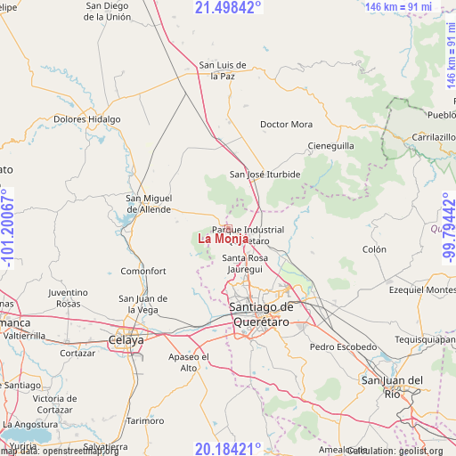
La Monja GPS coordinates[2]
20° 50' 33.9" North, 100° 29' 51.144" West
| Map corner | latitude | longitude |
|---|---|---|
| Upper-left | 21.49842°, | -101.20067° |
| Center: | 20.84275°, | -100.49754° |
| Lower-right: | 20.18421°, | -99.79442° |
| Map W x H: | 146.1×146.1 km | = 90.8×90.8mi |
| max Lat: | 32.7° ⇑26.1% North |
| La Monja: | 20.84275° |
| min Lat: | ⇓73.9% South 14.53588° |
| min Long | La Monja | max Long |
| -117.105° | -100.49754° | -86.73105° |
| W 30.5%⇐ | ⇒69.5% E |
Elevation
Elevation of La Monja is 2089 m = 6854 ft, and this is 835.3 m = 2740 ft above average elevation for this country.
| Max E: |
3497 m = 11473 ft | 22% |
| La Monja | 2089 m 6854 ft | |
| Avg. | 1253.7 m = 4113 ft | |
Min E: |
-1 m = -3 ft | 78% |
See also: Mexico elevation on elevation.city.
Geographical zone
La Monja is located in North Torrid zone (between Equator and Tropic of Cancer). Distance of this Northern Tropic circle is 288.4 km =179.2 mi to North.| Distance of | km | miles | from La Monja |
|---|---|---|---|
| North Pole | 7689.6 | 4778.1 | to North |
| Arctic Circle | 5083.7 | 3158.9 | to North |
| Tropic Cancer | 288.4 | 179.2 | to North |
| Equator | 2317.5 | 1440 | to South |


Nearby cities:
15 places around La Monja: (largest is in red/bold)
• Buenavista
3.6 km =2.2 mi,  126°
126°
• Cerro de la Cruz
3.1 km =1.9 mi,  186°
186°
• Corea
6.7 km =4.2 mi, 132°
• Estancia de la Rochera
8 km =5 mi, 187°
• Jofre
8.1 km =5 mi,  83°
83°
• Jofrito
8.4 km =5.2 mi, 75°
• La Barreta
1.9 km =1.2 mi,  209°
209°
• La Carbonera
4.2 km =2.6 mi, 189°
• La Luz
6.8 km =4.2 mi,  64°
64°
• Moral de Puerto de Nieto
5.9 km =3.7 mi,  343°
343°
• Pie de Gallo
6.6 km =4.1 mi,  175°
175°
• Puerto de Aguirre
7.9 km =4.9 mi,  120°
120°
• Puerto de Nieto
6.7 km =4.2 mi,  321°
321°
• San Isidro Buenavista
7.8 km =4.8 mi,  140°
140°
• Santas Marías
6.2 km =3.9 mi,  307°
307°
Sources, notices
• [Note1] Compared only with cities in Mexico existing in our database
• [Src1] Map data: © OpenStreetMap contributors (CC-BY-SA)
• [Src2] Other city data from geonames.org with taken over terms of usage.
• [Src3] Geographical zone / Annual Mean Temperature by Robert A. Rohde @ Wikipedia
