La Mazata geodata
La Mazata (Jalisco) is a populated place; located in Mexico in America/Mexico_City (GMT-6) time zone. With population of 757 people, there are 11569 cities with bigger population in this country. Compared to other cities in Mexico, 74.5% of cities are located further ↓South; 90.2% of cities are located further →East and 50.4% of cities have higher elevation than La Mazata. Note1


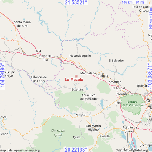
La Mazata GPS coordinates[2]
20° 52' 46.956" North, 104° 5' 19.788" West
| Map corner | latitude | longitude |
|---|---|---|
| Upper-left | 21.53521°, | -104.79196° |
| Center: | 20.87971°, | -104.08883° |
| Lower-right: | 20.22133°, | -103.38571° |
| Map W x H: | 146.1×146.1 km | = 90.8×90.8mi |
| max Lat: | 32.7° ⇑25.5% North |
| La Mazata: | 20.87971° |
| min Lat: | ⇓74.5% South 14.53588° |
| min Long | La Mazata | max Long |
| -117.105° | -104.08883° | -86.73105° |
| W 9.8%⇐ | ⇒90.2% E |
Elevation
Elevation of La Mazata is 1410 m = 4626 ft, and this is 156.3 m = 513 ft above average elevation for this country.
| Max E: |
3497 m = 11473 ft | 50.4% |
| La Mazata | 1410 m 4626 ft | |
| Avg. | 1253.7 m = 4113 ft | |
Min E: |
-1 m = -3 ft | 49.6% |
See also: Mexico elevation on elevation.city.
Geographical zone
La Mazata is located in North Torrid zone (between Equator and Tropic of Cancer). Distance of this Northern Tropic circle is 284.3 km =176.7 mi to North.| Distance of | km | miles | from La Mazata |
|---|---|---|---|
| North Pole | 7685.5 | 4775.5 | to North |
| Arctic Circle | 5079.6 | 3156.3 | to North |
| Tropic Cancer | 284.3 | 176.7 | to North |
| Equator | 2321.6 | 1442.6 | to South |


Nearby cities:
15 places around La Mazata: (largest is in red/bold)
• Antonio Escobedo
11.6 km =7.2 mi,  139°
139°
• Etzatlán
12.4 km =7.7 mi,  174°
174°
• La Estancia de Ayones
0.3 km =0.2 mi,  31°
31°
• La Joya
12.2 km =7.6 mi,  107°
107°
• La Quemada
11 km =6.8 mi,  22°
22°
• La Venta de Nochitiltic
16.5 km =10.3 mi,  339°
339°
• Magdalena
11.9 km =7.4 mi,  75°
75°
• Oconahua
17.2 km =10.7 mi,  207°
207°
• San Andrés
5 km =3.1 mi,  0°
0°
• San Juanito de Escobedo
13.1 km =8.1 mi, 136°
• San Marcos
14.8 km =9.2 mi,  229°
229°
• San Pedro
7.4 km =4.6 mi,  157°
157°
• San Simón
14.7 km =9.1 mi, 33°
• Santa Rosalía
7 km =4.3 mi,  177°
177°
• Santo Tomás
13.3 km =8.3 mi,  348°
348°
Sources, notices
• [Note1] Compared only with cities in Mexico existing in our database
• [Src1] Map data: © OpenStreetMap contributors (CC-BY-SA)
• [Src2] Other city data from geonames.org with taken over terms of usage.
• [Src3] Geographical zone / Annual Mean Temperature by Robert A. Rohde @ Wikipedia
