La Quemada geodata
La Quemada (Jalisco) is a populated place; located in Mexico in America/Mexico_City (GMT-6) time zone. With population of 1,238 people, there are 7007 cities with bigger population in this country. Compared to other cities in Mexico, 76.1% of cities are located further ↓South; 90.1% of cities are located further →East and 50.6% of cities have higher elevation than La Quemada. Note1


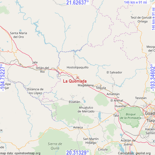
La Quemada GPS coordinates[2]
20° 58' 16.572" North, 104° 2' 56.904" West
| Map corner | latitude | longitude |
|---|---|---|
| Upper-left | 21.62637°, | -104.75227° |
| Center: | 20.97127°, | -104.04914° |
| Lower-right: | 20.31329°, | -103.34602° |
| Map W x H: | 146×146 km | = 90.7×90.7mi |
| max Lat: | 32.7° ⇑23.9% North |
| La Quemada: | 20.97127° |
| min Lat: | ⇓76.1% South 14.53588° |
| min Long | La Quemada | max Long |
| -117.105° | -104.04914° | -86.73105° |
| W 9.9%⇐ | ⇒90.1% E |
Elevation
Elevation of La Quemada is 1399 m = 4590 ft, and this is 145.3 m = 477 ft above average elevation for this country.
| Max E: |
3497 m = 11473 ft | 50.6% |
| La Quemada | 1399 m 4590 ft | |
| Avg. | 1253.7 m = 4113 ft | |
Min E: |
-1 m = -3 ft | 49.4% |
See also: Mexico elevation on elevation.city.
Geographical zone
La Quemada is located in North Torrid zone (between Equator and Tropic of Cancer). Distance of this Northern Tropic circle is 274.1 km =170.3 mi to North.| Distance of | km | miles | from La Quemada |
|---|---|---|---|
| North Pole | 7675.3 | 4769.2 | to North |
| Arctic Circle | 5069.4 | 3150 | to North |
| Tropic Cancer | 274.1 | 170.3 | to North |
| Equator | 2331.8 | 1448.9 | to South |


Nearby cities:
15 places around La Quemada: (largest is in red/bold)
• Antonio Escobedo
19.3 km =12 mi,  169°
169°
• El Llano de los Vela
14.3 km =8.9 mi,  76°
76°
• Hostotipaquillo
9.9 km =6.2 mi,  358°
358°
• La Estancia de Ayones
10.7 km =6.6 mi,  201°
201°
• La Joya
15.8 km =9.8 mi,  151°
151°
• La Mazata
11 km =6.8 mi, 202°
• La Venta de Nochitiltic
11.3 km =7 mi,  297°
297°
• Magdalena
10.2 km =6.3 mi,  133°
133°
• San Andrés
6.6 km =4.1 mi,  217°
217°
• San Martín de las Cañas
20.1 km =12.5 mi,  98°
98°
• San Pedro
17.1 km =10.6 mi,  184°
184°
• San Simón
4.5 km =2.8 mi,  62°
62°
• Santa Rosalía
17.6 km =10.9 mi,  192°
192°
• Santa Teresa
17.4 km =10.8 mi,  110°
110°
• Santo Tomás
7.4 km =4.6 mi,  292°
292°
Sources, notices
• [Note1] Compared only with cities in Mexico existing in our database
• [Src1] Map data: © OpenStreetMap contributors (CC-BY-SA)
• [Src2] Other city data from geonames.org with taken over terms of usage.
• [Src3] Geographical zone / Annual Mean Temperature by Robert A. Rohde @ Wikipedia
