La Joya geodata
La Joya (Jalisco) is a populated place; located in Mexico in America/Mexico_City (GMT-6) time zone. With population of 977 people, there are 8897 cities with bigger population in this country. Compared to other cities in Mexico, 74% of cities are located further ↓South; 89.9% of cities are located further →East and 51.3% of cities have higher elevation than La Joya. Note1


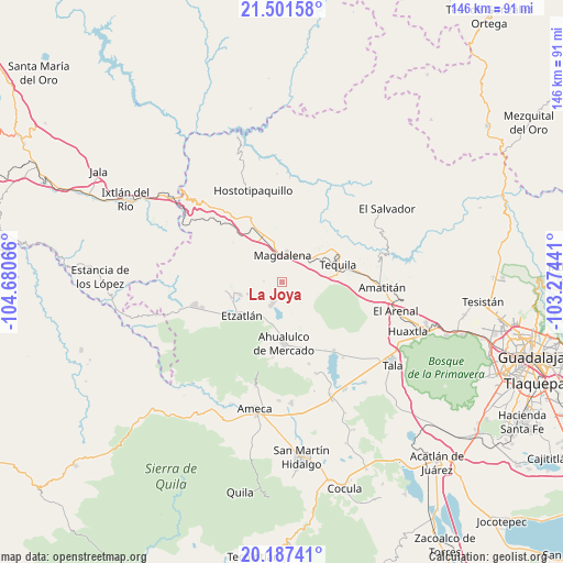
La Joya GPS coordinates[2]
20° 50' 45.348" North, 103° 58' 39.108" West
| Map corner | latitude | longitude |
|---|---|---|
| Upper-left | 21.50158°, | -104.68066° |
| Center: | 20.84593°, | -103.97753° |
| Lower-right: | 20.18741°, | -103.27441° |
| Map W x H: | 146.1×146.1 km | = 90.8×90.8mi |
| max Lat: | 32.7° ⇑26% North |
| La Joya: | 20.84593° |
| min Lat: | ⇓74% South 14.53588° |
| min Long | La Joya | max Long |
| -117.105° | -103.97753° | -86.73105° |
| W 10.1%⇐ | ⇒89.9% E |
Elevation
Elevation of La Joya is 1371 m = 4498 ft, and this is 117.3 m = 385 ft above average elevation for this country.
| Max E: |
3497 m = 11473 ft | 51.3% |
| La Joya | 1371 m 4498 ft | |
| Avg. | 1253.7 m = 4113 ft | |
Min E: |
-1 m = -3 ft | 48.7% |
See also: Mexico elevation on elevation.city.
Geographical zone
La Joya is located in North Torrid zone (between Equator and Tropic of Cancer). Distance of this Northern Tropic circle is 288.1 km =179 mi to North.| Distance of | km | miles | from La Joya |
|---|---|---|---|
| North Pole | 7689.2 | 4777.8 | to North |
| Arctic Circle | 5083.3 | 3158.6 | to North |
| Tropic Cancer | 288.1 | 179 | to North |
| Equator | 2317.9 | 1440.3 | to South |


Nearby cities:
15 places around La Joya: (largest is in red/bold)
• Ahualulco de Mercado
16.1 km =10 mi,  178°
178°
• Antonio Escobedo
6.5 km =4 mi,  218°
218°
• Etzatlán
13.5 km =8.4 mi,  230°
230°
• La Estancia de Ayones
12.1 km =7.5 mi,  289°
289°
• La Estancita
12.3 km =7.6 mi,  189°
189°
• La Mazata
12.2 km =7.6 mi, 287°
• La Quemada
15.8 km =9.8 mi,  331°
331°
• Magdalena
6.8 km =4.2 mi,  359°
359°
• San Andrés
14.4 km =8.9 mi,  307°
307°
• San Juanito de Escobedo
6.3 km =3.9 mi,  204°
204°
• San Pedro
9.3 km =5.8 mi,  250°
250°
• San Simón
16.3 km =10.1 mi,  347°
347°
• Santa Rosalía
11.7 km =7.3 mi, 253°
• Santa Teresa
11.8 km =7.3 mi,  48°
48°
• Tequila
15.2 km =9.4 mi,  74°
74°
Sources, notices
• [Note1] Compared only with cities in Mexico existing in our database
• [Src1] Map data: © OpenStreetMap contributors (CC-BY-SA)
• [Src2] Other city data from geonames.org with taken over terms of usage.
• [Src3] Geographical zone / Annual Mean Temperature by Robert A. Rohde @ Wikipedia
