El Saúz geodata
El Saúz (Querétaro) is a populated place; located in Mexico in America/Mexico_City (GMT-6) time zone. With population of 6,569 people, there are 1426 cities with bigger population in this country. Compared to other cities in Mexico, 67.3% of cities are located further ↓South; 65.4% of cities are located further →East and 69% of cities have lower elevation than El Saúz. Note1


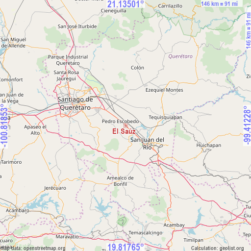
El Saúz GPS coordinates[2]
20° 28' 39.864" North, 100° 6' 55.44" West
| Map corner | latitude | longitude |
|---|---|---|
| Upper-left | 21.13501°, | -100.81853° |
| Center: | 20.47774°, | -100.1154° |
| Lower-right: | 19.81765°, | -99.41228° |
| Map W x H: | 146.5×146.5 km | = 91×91mi |
| max Lat: | 32.7° ⇑32.7% North |
| El Saúz: | 20.47774° |
| min Lat: | ⇓67.3% South 14.53588° |
| min Long | El Saúz | max Long |
| -117.105° | -100.1154° | -86.73105° |
| W 34.6%⇐ | ⇒65.4% E |
Elevation
Elevation of El Saúz is 1908 m = 6260 ft, and this is 654.3 m = 2147 ft above average elevation for this country.
| Max E: |
3497 m = 11473 ft | 31% |
| El Saúz | 1908 m 6260 ft | |
| Avg. | 1253.7 m = 4113 ft | |
Min E: |
-1 m = -3 ft | 69% |
See also: Mexico elevation on elevation.city.
Geographical zone
El Saúz is located in North Torrid zone (between Equator and Tropic of Cancer). Distance of this Northern Tropic circle is 329 km =204.4 mi to North.| Distance of | km | miles | from El Saúz |
|---|---|---|---|
| North Pole | 7730.2 | 4803.3 | to North |
| Arctic Circle | 5124.3 | 3184.1 | to North |
| Tropic Cancer | 329 | 204.4 | to North |
| Equator | 2276.9 | 1414.8 | to South |


Nearby cities:
15 places around El Saúz: (largest is in red/bold)
• Arcila
7.5 km =4.7 mi,  175°
175°
• El Organal
6.3 km =3.9 mi,  90°
90°
• Guadalupe Septién
5.5 km =3.4 mi,  2°
2°
• Ignacio Pérez
5 km =3.1 mi, 4°
• La D
5.7 km =3.5 mi,  223°
223°
• La Estancia
8.1 km =5 mi,  140°
140°
• La Lira
4.8 km =3 mi,  267°
267°
• La Palma
7.8 km =4.8 mi,  309°
309°
• Laguna de Lourdes
6.9 km =4.3 mi, 88°
• Pedro Escobedo
3.7 km =2.3 mi, 310°
• Quintanares
5.9 km =3.7 mi,  335°
335°
• San Antonio la D
8 km =5 mi, 218°
• San Clemente
5.2 km =3.2 mi,  37°
37°
• San Germán
6.5 km =4 mi,  108°
108°
• San Javier
6.2 km =3.9 mi,  115°
115°
Sources, notices
• [Note1] Compared only with cities in Mexico existing in our database
• [Src1] Map data: © OpenStreetMap contributors (CC-BY-SA)
• [Src2] Other city data from geonames.org with taken over terms of usage.
• [Src3] Geographical zone / Annual Mean Temperature by Robert A. Rohde @ Wikipedia
