La Joya de Calvillo geodata
La Joya de Calvillo (Guanajuato) is a populated place; located in Mexico in America/Mexico_City (GMT-6) time zone. With population of 1,215 people, there are 7154 cities with bigger population in this country. Compared to other cities in Mexico, 72.5% of cities are located further ↓South; 78.2% of cities are located further →East and 62.9% of cities have lower elevation than La Joya de Calvillo. Note1


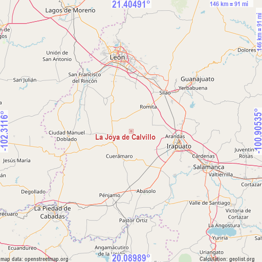
La Joya de Calvillo GPS coordinates[2]
20° 44' 55.788" North, 101° 36' 30.492" West
| Map corner | latitude | longitude |
|---|---|---|
| Upper-left | 21.40491°, | -102.3116° |
| Center: | 20.74883°, | -101.60847° |
| Lower-right: | 20.08989°, | -100.90535° |
| Map W x H: | 146.2×146.2 km | = 90.8×90.8mi |
| max Lat: | 32.7° ⇑27.5% North |
| La Joya de Calvillo: | 20.74883° |
| min Lat: | ⇓72.5% South 14.53588° |
| min Long | La Joya de Calv | max Long |
| -117.105° | -101.60847° | -86.73105° |
| W 21.8%⇐ | ⇒78.2% E |
Elevation
Elevation of La Joya de Calvillo is 1776 m = 5827 ft, and this is 522.3 m = 1714 ft above average elevation for this country.
| Max E: |
3497 m = 11473 ft | 37.1% |
| La Joya de Calvillo | 1776 m 5827 ft | |
| Avg. | 1253.7 m = 4113 ft | |
Min E: |
-1 m = -3 ft | 62.9% |
See also: Mexico elevation on elevation.city.
Geographical zone
La Joya de Calvillo is located in North Torrid zone (between Equator and Tropic of Cancer). Distance of this Northern Tropic circle is 298.9 km =185.7 mi to North.| Distance of | km | miles | from La Joya de Calvillo |
|---|---|---|---|
| North Pole | 7700 | 4784.6 | to North |
| Arctic Circle | 5094.1 | 3165.3 | to North |
| Tropic Cancer | 298.9 | 185.7 | to North |
| Equator | 2307.1 | 1433.6 | to South |


Nearby cities:
15 places around La Joya de Calvillo: (largest is in red/bold)
• Chamacua
9.3 km =5.8 mi,  152°
152°
• Cruz de Aguilar
7.5 km =4.7 mi,  11°
11°
• El Carmen de Sánchez
6.3 km =3.9 mi,  43°
43°
• El Mármol
11.1 km =6.9 mi,  15°
15°
• Gavia de Rionda
9.5 km =5.9 mi,  354°
354°
• Los Amoles
5.5 km =3.4 mi,  339°
339°
• Monte de Hoyos
8.9 km =5.5 mi,  322°
322°
• Puerto de la Cruz
5.8 km =3.6 mi,  156°
156°
• San Antonio Cerro Prieto
4.9 km =3 mi,  238°
238°
• San Clemente
9.9 km =6.2 mi,  45°
45°
• San Isidro Ojo de Agua
6.2 km =3.9 mi,  301°
301°
• Santa Efigenia
9.3 km =5.8 mi,  309°
309°
• Santa Rosa de Rivas
8.3 km =5.2 mi,  64°
64°
• Santa Rosalía de Gavia
8.3 km =5.2 mi, 336°
• Vista Hermosa
9.5 km =5.9 mi,  87°
87°
Sources, notices
• [Note1] Compared only with cities in Mexico existing in our database
• [Src1] Map data: © OpenStreetMap contributors (CC-BY-SA)
• [Src2] Other city data from geonames.org with taken over terms of usage.
• [Src3] Geographical zone / Annual Mean Temperature by Robert A. Rohde @ Wikipedia
