El Mármol geodata
El Mármol (Guanajuato) is a populated place; located in Mexico in America/Mexico_City (GMT-6) time zone. With population of 565 people, there are 15122 cities with bigger population in this country. Compared to other cities in Mexico, 73.9% of cities are located further ↓South; 78% of cities are located further →East and 61.1% of cities have lower elevation than El Mármol. Note1


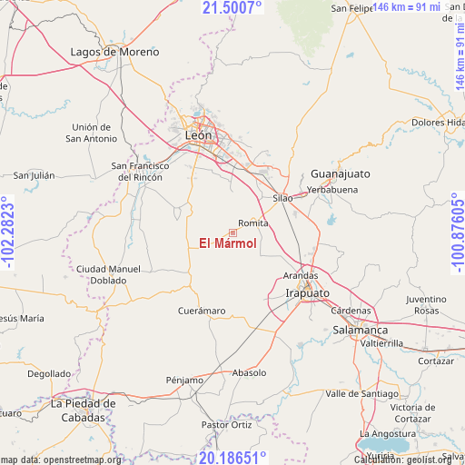
El Mármol GPS coordinates[2]
20° 50' 42.144" North, 101° 34' 45.012" West
| Map corner | latitude | longitude |
|---|---|---|
| Upper-left | 21.5007°, | -102.2823° |
| Center: | 20.84504°, | -101.57917° |
| Lower-right: | 20.18651°, | -100.87605° |
| Map W x H: | 146.1×146.1 km | = 90.8×90.8mi |
| max Lat: | 32.7° ⇑26.1% North |
| El Mármol: | 20.84504° |
| min Lat: | ⇓73.9% South 14.53588° |
| min Long | El Mármol | max Long |
| -117.105° | -101.57917° | -86.73105° |
| W 22%⇐ | ⇒78% E |
Elevation
Elevation of El Mármol is 1745 m = 5725 ft, and this is 491.3 m = 1612 ft above average elevation for this country.
| Max E: |
3497 m = 11473 ft | 38.9% |
| El Mármol | 1745 m 5725 ft | |
| Avg. | 1253.7 m = 4113 ft | |
Min E: |
-1 m = -3 ft | 61.1% |
See also: Mexico elevation on elevation.city.
Geographical zone
El Mármol is located in North Torrid zone (between Equator and Tropic of Cancer). Distance of this Northern Tropic circle is 288.2 km =179.1 mi to North.| Distance of | km | miles | from El Mármol |
|---|---|---|---|
| North Pole | 7689.3 | 4777.9 | to North |
| Arctic Circle | 5083.4 | 3158.7 | to North |
| Tropic Cancer | 288.2 | 179.1 | to North |
| Equator | 2317.8 | 1440.2 | to South |


Nearby cities:
15 places around El Mármol: (largest is in red/bold)
• Colonia Rafael Corrales Ayala
9.1 km =5.7 mi,  45°
45°
• Cruz de Aguilar
3.7 km =2.3 mi,  205°
205°
• El Camaleón
7.3 km =4.5 mi,  310°
310°
• El Carmen de Sánchez
6.3 km =3.9 mi,  168°
168°
• Gavia de Rionda
4.1 km =2.5 mi,  251°
251°
• Los Amoles
7.4 km =4.6 mi,  221°
221°
• Lourdes
2.8 km =1.7 mi,  327°
327°
• Monte de Hoyos
9.1 km =5.7 mi, 246°
• Romita
7.1 km =4.4 mi,  65°
65°
• San Clemente
5.4 km =3.4 mi,  132°
132°
• San Gonzalo
4.8 km =3 mi,  10°
10°
• San Miguel del Guaricho
4.3 km =2.7 mi,  95°
95°
• Santa Rosa de Rivas
8.4 km =5.2 mi,  147°
147°
• Santa Rosalía de Gavia
7 km =4.3 mi,  243°
243°
• Silva
6.4 km =4 mi,  27°
27°
Sources, notices
• [Note1] Compared only with cities in Mexico existing in our database
• [Src1] Map data: © OpenStreetMap contributors (CC-BY-SA)
• [Src2] Other city data from geonames.org with taken over terms of usage.
• [Src3] Geographical zone / Annual Mean Temperature by Robert A. Rohde @ Wikipedia
