Huitrón geodata
Huitrón (Coahuila) is a populated place; located in Mexico in America/Monterrey (GMT-6) time zone. With population of 1,511 people, there are 5712 cities with bigger population in this country. Compared to other cities in Mexico, 94.7% of cities are located further ↓South; 87.4% of cities are located further →East and 58% of cities have higher elevation than Huitrón. Note1


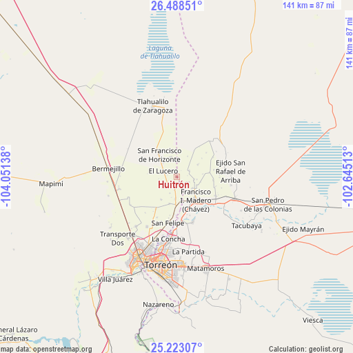
Huitrón GPS coordinates[2]
25° 51' 26.928" North, 103° 20' 53.7" West
| Map corner | latitude | longitude |
|---|---|---|
| Upper-left | 26.48851°, | -104.05138° |
| Center: | 25.85748°, | -103.34825° |
| Lower-right: | 25.22307°, | -102.64513° |
| Map W x H: | 140.7×140.7 km | = 87.4×87.4mi |
| max Lat: | 32.7° ⇑5.3% North |
| Huitrón: | 25.85748° |
| min Lat: | ⇓94.7% South 14.53588° |
| min Long | Huitrón | max Long |
| -117.105° | -103.34825° | -86.73105° |
| W 12.6%⇐ | ⇒87.4% E |
Elevation
Elevation of Huitrón is 1104 m = 3622 ft, and this is 149.7 m = 491 ft below average elevation for this country.
| Max E: |
3497 m = 11473 ft | 58% |
| Avg. | 1253.7 m = 4113 ft | |
| Huitrón | 1104 m = 3622 ft | |
Min E: |
-1 m = -3 ft | 42% |
See also: Mexico elevation on elevation.city.
Geographical zone
Huitrón is located in North temperate zone (between Tropic of Cancer and the Arctic Circle). Distance of this Northern Tropic circle is 269.2 km =167.3 mi to South.| Distance of | km | miles | from Huitrón |
|---|---|---|---|
| North Pole | 7132 | 4431.6 | to North |
| Arctic Circle | 4526.1 | 2812.4 | to North |
| Tropic Cancer | 269.2 | 167.3 | to South |
| Equator | 2875.1 | 1786.5 | to South |


Nearby cities:
15 places around Huitrón: (largest is in red/bold)
• Arturo Martínez Adame
4.5 km =2.8 mi,  230°
230°
• Banco Nacional
1.8 km =1.1 mi,  331°
331°
• Colón
8.1 km =5 mi,  96°
96°
• Coruña
5.7 km =3.5 mi,  63°
63°
• El Barro
5.3 km =3.3 mi,  240°
240°
• El Lequeitio
7 km =4.3 mi, 99°
• El Lucero
5.9 km =3.7 mi,  293°
293°
• Eureka de Media Luna (Eureka)
7 km =4.3 mi,  201°
201°
• Florencia
4.4 km =2.7 mi,  118°
118°
• Glorieta
6 km =3.7 mi,  184°
184°
• Hidalgo
8 km =5 mi, 124°
• Jiménez
3.1 km =1.9 mi, 196°
• Las Mercedes
5.5 km =3.4 mi,  111°
111°
• San Alberto
3.4 km =2.1 mi,  173°
173°
• Valle de Eureka
6.6 km =4.1 mi, 227°
Sources, notices
• [Note1] Compared only with cities in Mexico existing in our database
• [Src1] Map data: © OpenStreetMap contributors (CC-BY-SA)
• [Src2] Other city data from geonames.org with taken over terms of usage.
• [Src3] Geographical zone / Annual Mean Temperature by Robert A. Rohde @ Wikipedia
