Florencia geodata
Florencia (Coahuila) is a populated place; located in Mexico in America/Monterrey (GMT-6) time zone. With population of 940 people, there are 9266 cities with bigger population in this country. Compared to other cities in Mexico, 94.5% of cities are located further ↓South; 87.2% of cities are located further →East and 57.9% of cities have higher elevation than Florencia. Note1


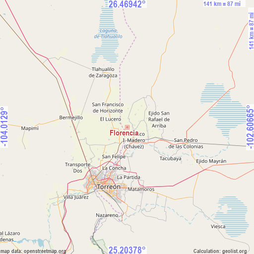
Florencia GPS coordinates[2]
25° 50' 17.844" North, 103° 18' 35.172" West
| Map corner | latitude | longitude |
|---|---|---|
| Upper-left | 26.46942°, | -104.0129° |
| Center: | 25.83829°, | -103.30977° |
| Lower-right: | 25.20378°, | -102.60665° |
| Map W x H: | 140.7×140.7 km | = 87.4×87.4mi |
| max Lat: | 32.7° ⇑5.5% North |
| Florencia: | 25.83829° |
| min Lat: | ⇓94.5% South 14.53588° |
| min Long | Florencia | max Long |
| -117.105° | -103.30977° | -86.73105° |
| W 12.8%⇐ | ⇒87.2% E |
Elevation
Elevation of Florencia is 1106 m = 3629 ft, and this is 147.7 m = 485 ft below average elevation for this country.
| Max E: |
3497 m = 11473 ft | 57.9% |
| Avg. | 1253.7 m = 4113 ft | |
| Florencia | 1106 m = 3629 ft | |
Min E: |
-1 m = -3 ft | 42.1% |
See also: Mexico elevation on elevation.city.
Geographical zone
Florencia is located in North temperate zone (between Tropic of Cancer and the Arctic Circle). Distance of this Northern Tropic circle is 267 km =165.9 mi to South.| Distance of | km | miles | from Florencia |
|---|---|---|---|
| North Pole | 7134.1 | 4432.9 | to North |
| Arctic Circle | 4528.2 | 2813.7 | to North |
| Tropic Cancer | 267 | 165.9 | to South |
| Equator | 2872.9 | 1785.1 | to South |


Nearby cities:
15 places around Florencia: (largest is in red/bold)
• Arturo Martínez Adame
7.4 km =4.6 mi,  264°
264°
• Banco Nacional
6 km =3.7 mi,  308°
308°
• Colón
4.4 km =2.7 mi,  74°
74°
• Coruña
4.8 km =3 mi,  14°
14°
• El Lequeitio
3.2 km =2 mi, 73°
• El Porvenir (El Porvenir de Arriba)
7.3 km =4.5 mi,  192°
192°
• Eureka de Media Luna (Eureka)
7.7 km =4.8 mi,  235°
235°
• Glorieta
5.8 km =3.6 mi,  228°
228°
• Hidalgo
3.6 km =2.2 mi,  131°
131°
• Huitrón
4.4 km =2.7 mi,  298°
298°
• Jiménez
4.8 km =3 mi, 259°
• Las Mercedes
1.2 km =0.7 mi,  83°
83°
• San Alberto
3.7 km =2.3 mi,  249°
249°
• Santa María
7.4 km =4.6 mi,  63°
63°
• Virginias
5.6 km =3.5 mi,  138°
138°
Sources, notices
• [Note1] Compared only with cities in Mexico existing in our database
• [Src1] Map data: © OpenStreetMap contributors (CC-BY-SA)
• [Src2] Other city data from geonames.org with taken over terms of usage.
• [Src3] Geographical zone / Annual Mean Temperature by Robert A. Rohde @ Wikipedia
