Huitchaca geodata
Huitchaca (Sonora) is a populated place; located in Mexico in America/Hermosillo (GMT-7) time zone. With population of 624 people, there are 13853 cities with bigger population in this country. Compared to other cities in Mexico, 96.1% of cities are located further ↓South; 97.8% of cities are located further →East and 92.5% of cities have higher elevation than Huitchaca. Note1


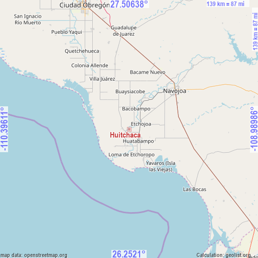
Huitchaca GPS coordinates[2]
26° 52' 51.528" North, 109° 41' 34.728" West
| Map corner | latitude | longitude |
|---|---|---|
| Upper-left | 27.50638°, | -110.39611° |
| Center: | 26.88098°, | -109.69298° |
| Lower-right: | 26.2521°, | -108.98986° |
| Map W x H: | 139.5×139.5 km | = 86.7×86.7mi |
| max Lat: | 32.7° ⇑3.9% North |
| Huitchaca: | 26.88098° |
| min Lat: | ⇓96.1% South 14.53588° |
| min Long | Huitchaca | max Long |
| -117.105° | -109.69298° | -86.73105° |
| W 2.2%⇐ | ⇒97.8% E |
Elevation
Elevation of Huitchaca is 18 m = 59 ft, and this is 1235.7 m = 4054 ft below average elevation for this country.
| Max E: |
3497 m = 11473 ft | 92.5% |
| Avg. | 1253.7 m = 4113 ft | |
| Huitchaca | 18 m = 59 ft | |
Min E: |
-1 m = -3 ft | 7.5% |
See also: Mexico elevation on elevation.city.
Geographical zone
Huitchaca is located in North temperate zone (between Tropic of Cancer and the Arctic Circle). Distance of this Northern Tropic circle is 383 km =238 mi to South.| Distance of | km | miles | from Huitchaca |
|---|---|---|---|
| North Pole | 7018.2 | 4360.9 | to North |
| Arctic Circle | 4412.3 | 2741.7 | to North |
| Tropic Cancer | 383 | 238 | to South |
| Equator | 2988.9 | 1857.2 | to South |


Nearby cities:
15 places around Huitchaca: (largest is in red/bold)
• 17 de Octubre
9.3 km =5.8 mi,  185°
185°
• Basconcobe
8.6 km =5.3 mi,  16°
16°
• El Caro
2.7 km =1.7 mi,  235°
235°
• El Sahuaral
5.7 km =3.5 mi,  27°
27°
• Etchojoa
7.4 km =4.6 mi,  63°
63°
• Huatabampo
7.9 km =4.9 mi,  140°
140°
• Juraré
8.8 km =5.5 mi, 185°
• La Bocana
2.6 km =1.6 mi,  74°
74°
• Las Guayabas
1.9 km =1.2 mi,  11°
11°
• Las Parras
5.2 km =3.2 mi,  206°
206°
• Mochidaco
7 km =4.3 mi, 28°
• Navobaxia
5.6 km =3.5 mi,  157°
157°
• Pozo Dulce
7.2 km =4.5 mi, 236°
• Sahuaral de Otero
3.9 km =2.4 mi,  276°
276°
• Villa Tres Cruces
3.7 km =2.3 mi,  42°
42°
Sources, notices
• [Note1] Compared only with cities in Mexico existing in our database
• [Src1] Map data: © OpenStreetMap contributors (CC-BY-SA)
• [Src2] Other city data from geonames.org with taken over terms of usage.
• [Src3] Geographical zone / Annual Mean Temperature by Robert A. Rohde @ Wikipedia
