Basconcobe geodata
Basconcobe (Sonora) is a populated place; located in Mexico in America/Hermosillo (GMT-7) time zone. With population of 2,926 people, there are 3045 cities with bigger population in this country. Compared to other cities in Mexico, 96.2% of cities are located further ↓South; 97.7% of cities are located further →East and 93.5% of cities have higher elevation than Basconcobe. Note1


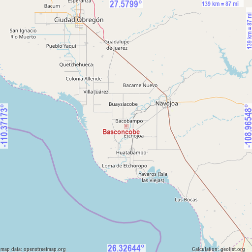
Basconcobe GPS coordinates[2]
26° 57' 17.676" North, 109° 40' 6.96" West
| Map corner | latitude | longitude |
|---|---|---|
| Upper-left | 27.5799°, | -110.37173° |
| Center: | 26.95491°, | -109.6686° |
| Lower-right: | 26.32644°, | -108.96548° |
| Map W x H: | 139.4×139.4 km | = 86.6×86.6mi |
| max Lat: | 32.7° ⇑3.8% North |
| Basconcobe: | 26.95491° |
| min Lat: | ⇓96.2% South 14.53588° |
| min Long | Basconcobe | max Long |
| -117.105° | -109.6686° | -86.73105° |
| W 2.3%⇐ | ⇒97.7% E |
Elevation
Elevation of Basconcobe is 16 m = 52 ft, and this is 1237.7 m = 4061 ft below average elevation for this country.
| Max E: |
3497 m = 11473 ft | 93.5% |
| Avg. | 1253.7 m = 4113 ft | |
| Basconcobe | 16 m = 52 ft | |
Min E: |
-1 m = -3 ft | 6.5% |
See also: Mexico elevation on elevation.city.
Geographical zone
Basconcobe is located in North temperate zone (between Tropic of Cancer and the Arctic Circle). Distance of this Northern Tropic circle is 391.2 km =243.1 mi to South.| Distance of | km | miles | from Basconcobe |
|---|---|---|---|
| North Pole | 7010 | 4355.8 | to North |
| Arctic Circle | 4404.1 | 2736.6 | to North |
| Tropic Cancer | 391.2 | 243.1 | to South |
| Equator | 2997.1 | 1862.3 | to South |


Nearby cities:
15 places around Basconcobe: (largest is in red/bold)
• Bacobampo
3.4 km =2.1 mi,  26°
26°
• El Rodeo
7.1 km =4.4 mi,  21°
21°
• El Sahuaral
3.2 km =2 mi,  176°
176°
• Etchojoa
6.5 km =4 mi,  139°
139°
• Guayparín
2.5 km =1.6 mi,  58°
58°
• Huitchaca
8.6 km =5.3 mi,  196°
196°
• La Bocana
7.5 km =4.7 mi, 179°
• Las Guayabas
6.7 km =4.2 mi, 197°
• Las Playitas
6.4 km =4 mi, 58°
• Mochidaco
2.2 km =1.4 mi,  155°
155°
• Mocorua
6.3 km =3.9 mi,  272°
272°
• Sahuaral de Otero
10 km =6.2 mi,  218°
218°
• San Pedro Río Mayo
8.2 km =5.1 mi, 26°
• San Pedro Viejo
8.3 km =5.2 mi, 33°
• Villa Tres Cruces
5.5 km =3.4 mi, 179°
Sources, notices
• [Note1] Compared only with cities in Mexico existing in our database
• [Src1] Map data: © OpenStreetMap contributors (CC-BY-SA)
• [Src2] Other city data from geonames.org with taken over terms of usage.
• [Src3] Geographical zone / Annual Mean Temperature by Robert A. Rohde @ Wikipedia
