Guadalupe de Lerma geodata
Guadalupe de Lerma (Jalisco) is a populated place; located in Mexico in America/Mexico_City (GMT-6) time zone. With population of 1,140 people, there are 7619 cities with bigger population in this country. Compared to other cities in Mexico, 64.4% of cities are located further ↓South; 83.3% of cities are located further →East and 53% of cities have lower elevation than Guadalupe de Lerma. Note1


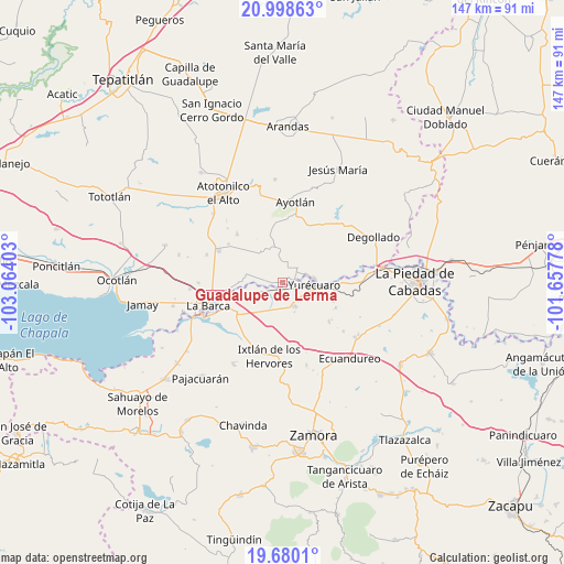
Guadalupe de Lerma GPS coordinates[2]
20° 20' 26.772" North, 102° 21' 39.24" West
| Map corner | latitude | longitude |
|---|---|---|
| Upper-left | 20.99863°, | -103.06403° |
| Center: | 20.34077°, | -102.3609° |
| Lower-right: | 19.6801°, | -101.65778° |
| Map W x H: | 146.6×146.6 km | = 91.1×91.1mi |
| max Lat: | 32.7° ⇑35.6% North |
| Guadalupe de Lerma: | 20.34077° |
| min Lat: | ⇓64.4% South 14.53588° |
| min Long | Guadalupe de Le | max Long |
| -117.105° | -102.3609° | -86.73105° |
| W 16.7%⇐ | ⇒83.3% E |
Elevation
Elevation of Guadalupe de Lerma is 1541 m = 5056 ft, and this is 287.3 m = 943 ft above average elevation for this country.
| Max E: |
3497 m = 11473 ft | 47% |
| Guadalupe de Lerma | 1541 m 5056 ft | |
| Avg. | 1253.7 m = 4113 ft | |
Min E: |
-1 m = -3 ft | 53% |
See also: Mexico elevation on elevation.city.
Geographical zone
Guadalupe de Lerma is located in North Torrid zone (between Equator and Tropic of Cancer). Distance of this Northern Tropic circle is 344.2 km =213.9 mi to North.| Distance of | km | miles | from Guadalupe de Lerma |
|---|---|---|---|
| North Pole | 7745.4 | 4812.8 | to North |
| Arctic Circle | 5139.5 | 3193.5 | to North |
| Tropic Cancer | 344.2 | 213.9 | to North |
| Equator | 2261.7 | 1405.4 | to South |


Nearby cities:
15 places around Guadalupe de Lerma: (largest is in red/bold)
• El Alvareño
9.1 km =5.7 mi,  240°
240°
• El Carmen
9.5 km =5.9 mi,  319°
319°
• El Tequesquite
8.7 km =5.4 mi,  119°
119°
• La Concepción
3.5 km =2.2 mi,  69°
69°
• La Noria
5.4 km =3.4 mi,  46°
46°
• La Ribera
8.2 km =5.1 mi,  83°
83°
• Los Charcos
9.8 km =6.1 mi,  210°
210°
• Los Pilares
2.1 km =1.3 mi,  217°
217°
• San Antonio de Rivas
7.1 km =4.4 mi,  278°
278°
• San Jerónimo
6.8 km =4.2 mi,  19°
19°
• Santa Elena de la Cruz
6.3 km =3.9 mi, 18°
• Santa Lucía
2.8 km =1.7 mi,  337°
337°
• Tanhuato de Guerrero
6.9 km =4.3 mi,  153°
153°
• Villanueva (Villa Nueva)
2.1 km =1.3 mi,  165°
165°
• Yurécuaro
8.1 km =5 mi,  93°
93°
Sources, notices
• [Note1] Compared only with cities in Mexico existing in our database
• [Src1] Map data: © OpenStreetMap contributors (CC-BY-SA)
• [Src2] Other city data from geonames.org with taken over terms of usage.
• [Src3] Geographical zone / Annual Mean Temperature by Robert A. Rohde @ Wikipedia
