Los Pilares geodata
Los Pilares (Michoacán) is a populated place; located in Mexico in America/Mexico_City (GMT-6) time zone. With population of 1,199 people, there are 7246 cities with bigger population in this country. Compared to other cities in Mexico, 64% of cities are located further ↓South; 83.4% of cities are located further →East and 53% of cities have lower elevation than Los Pilares. Note1


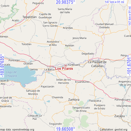
Los Pilares GPS coordinates[2]
20° 19' 32.952" North, 102° 22' 23.592" West
| Map corner | latitude | longitude |
|---|---|---|
| Upper-left | 20.98375°, | -103.07635° |
| Center: | 20.32582°, | -102.37322° |
| Lower-right: | 19.66508°, | -101.6701° |
| Map W x H: | 146.6×146.6 km | = 91.1×91.1mi |
| max Lat: | 32.7° ⇑36% North |
| Los Pilares: | 20.32582° |
| min Lat: | ⇓64% South 14.53588° |
| min Long | Los Pilares | max Long |
| -117.105° | -102.37322° | -86.73105° |
| W 16.6%⇐ | ⇒83.4% E |
Elevation
Elevation of Los Pilares is 1541 m = 5056 ft, and this is 287.3 m = 943 ft above average elevation for this country.
| Max E: |
3497 m = 11473 ft | 47% |
| Los Pilares | 1541 m 5056 ft | |
| Avg. | 1253.7 m = 4113 ft | |
Min E: |
-1 m = -3 ft | 53% |
See also: Mexico elevation on elevation.city.
Geographical zone
Los Pilares is located in North Torrid zone (between Equator and Tropic of Cancer). Distance of this Northern Tropic circle is 345.9 km =214.9 mi to North.| Distance of | km | miles | from Los Pilares |
|---|---|---|---|
| North Pole | 7747 | 4813.8 | to North |
| Arctic Circle | 5141.2 | 3194.6 | to North |
| Tropic Cancer | 345.9 | 214.9 | to North |
| Equator | 2260 | 1404.3 | to South |


Nearby cities:
15 places around Los Pilares: (largest is in red/bold)
• El Alvareño
7.2 km =4.5 mi,  247°
247°
• El Cuenqueño
8.8 km =5.5 mi,  271°
271°
• El Tequesquite
9.2 km =5.7 mi,  106°
106°
• Guadalupe de Lerma
2.1 km =1.3 mi,  37°
37°
• La Concepción
5.4 km =3.4 mi,  57°
57°
• La Noria
7.5 km =4.7 mi, 43°
• Los Charcos
7.7 km =4.8 mi,  208°
208°
• San Antonio de Rivas
6.3 km =3.9 mi,  295°
295°
• San Jerónimo
8.8 km =5.5 mi,  23°
23°
• San Ramón
9.2 km =5.7 mi,  290°
290°
• Santa Elena de la Cruz
8.3 km =5.2 mi, 23°
• Santa Lucía
4.3 km =2.7 mi,  2°
2°
• Tanhuato de Guerrero
6.3 km =3.9 mi,  135°
135°
• Villanueva (Villa Nueva)
1.8 km =1.1 mi,  100°
100°
• Yurécuaro
9.4 km =5.8 mi,  83°
83°
Sources, notices
• [Note1] Compared only with cities in Mexico existing in our database
• [Src1] Map data: © OpenStreetMap contributors (CC-BY-SA)
• [Src2] Other city data from geonames.org with taken over terms of usage.
• [Src3] Geographical zone / Annual Mean Temperature by Robert A. Rohde @ Wikipedia
