Villanueva (Villa Nueva) geodata
Villanueva (Villa Nueva) (Michoacán) is a populated place; located in Mexico in America/Mexico_City (GMT-6) time zone. With population of 618 people, there are 13956 cities with bigger population in this country. Compared to other cities in Mexico, 64% of cities are located further ↓South; 83.3% of cities are located further →East and 53% of cities have lower elevation than Villanueva (Villa Nueva). Note1
Current local time in Villanueva (Villa Nueva):
09:49 PM, TuesdayDifference from your time zone: hours


Villanueva (Villa Nueva) GPS coordinates[2]
20° 19' 22.008" North, 102° 21' 21.996" West
| Map corner | latitude | longitude |
|---|---|---|
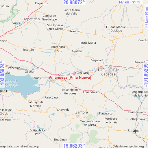
| Upper-left | 20.98072°, | -103.05924° |
| Center: | 20.32278°, | -102.35611° |
| Lower-right: | 19.66203°, | -101.65299° |
| Map W x H: | 146.6×146.6 km | = 91.1×91.1mi |
| max Lat: | 32.7° ⇑36% North |
| Villanueva (Villa Nueva): | 20.32278° |
| min Lat: | ⇓64% South 14.53588° |
| min Long | Villanueva (Vil | max Long |
| -117.105° | -102.35611° | -86.73105° |
| W 16.7%⇐ | ⇒83.3% E |
Elevation
Elevation of Villanueva (Villa Nueva) is 1541 m = 5056 ft, and this is 287.3 m = 943 ft above average elevation for this country.
| Max E: |
3497 m = 11473 ft | 47% |
| Villanueva (Villa Nueva) | 1541 m 5056 ft | |
| Avg. | 1253.7 m = 4113 ft | |
Min E: |
-1 m = -3 ft | 53% |
See also: Mexico elevation on elevation.city.
Geographical zone
Villanueva (Villa Nueva) is located in North Torrid zone (between Equator and Tropic of Cancer). Distance of this Northern Tropic circle is 346.2 km =215.1 mi to North.| Distance of | km | miles | from Villanueva (Villa Nueva) |
|---|---|---|---|
| North Pole | 7747.4 | 4814 | to North |
| Arctic Circle | 5141.5 | 3194.8 | to North |
| Tropic Cancer | 346.2 | 215.1 | to North |
| Equator | 2259.7 | 1404.1 | to South |


Nearby cities:
15 places around Villanueva (Villa Nueva): (largest is in red/bold)
• El Alvareño
8.8 km =5.5 mi,  253°
253°
• El Tequesquite
7.4 km =4.6 mi,  108°
108°
• Guadalupe de Lerma
2.1 km =1.3 mi,  345°
345°
• La Concepción
4.2 km =2.6 mi,  40°
40°
• La Noria
6.6 km =4.1 mi,  30°
30°
• La Ribera
8.2 km =5.1 mi,  69°
69°
• Los Charcos
8.4 km =5.2 mi,  219°
219°
• Los Pilares
1.8 km =1.1 mi,  280°
280°
• San Antonio de Rivas
8.1 km =5 mi,  292°
292°
• San Jerónimo
8.6 km =5.3 mi,  11°
11°
• Santa Elena de la Cruz
8.1 km =5 mi, 10°
• Santa Lucía
4.9 km =3 mi,  341°
341°
• Tanhuato de Guerrero
4.9 km =3 mi,  147°
147°
• Tarimoro
9.6 km =6 mi,  167°
167°
• Yurécuaro
7.7 km =4.8 mi,  78°
78°
Sources, notices
• [Note1] Compared only with cities in Mexico existing in our database
• [Src1] Map data: © OpenStreetMap contributors (CC-BY-SA)
• [Src2] Other city data from geonames.org with taken over terms of usage.
• [Src3] Geographical zone / Annual Mean Temperature by Robert A. Rohde @ Wikipedia
