General Simón Bolívar geodata
General Simón Bolívar (Durango) is a seat of a second-order administrative division; located in Mexico in America/Monterrey (GMT-6) time zone. With population of 1,321 people, there are 6568 cities with bigger population in this country. Compared to other cities in Mexico, 91.2% of cities are located further ↓South; 86.7% of cities are located further →East and 52.8% of cities have lower elevation than General Simón Bolívar. Note1


General Simón Bolívar GPS coordinates[2]
24° 41' 17.304" North, 103° 13' 33.636" West
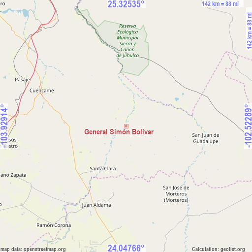
| Map corner | latitude | longitude |
|---|---|---|
| Upper-left | 25.32535°, | -103.92914° |
| Center: | 24.68814°, | -103.22601° |
| Lower-right: | 24.04766°, | -102.52289° |
| Map W x H: | 142.1×142.1 km | = 88.3×88.3mi |
| max Lat: | 32.7° ⇑8.8% North |
| General Simón Bolívar: | 24.68814° |
| min Lat: | ⇓91.2% South 14.53588° |
| min Long | General Simón | max Long |
| -117.105° | -103.22601° | -86.73105° |
| W 13.3%⇐ | ⇒86.7% E |
Elevation
Elevation of General Simón Bolívar is 1537 m = 5043 ft, and this is 283.3 m = 929 ft above average elevation for this country.
| Max E: |
3497 m = 11473 ft | 47.2% |
| General Simón Bolívar | 1537 m 5043 ft | |
| Avg. | 1253.7 m = 4113 ft | |
Min E: |
-1 m = -3 ft | 52.8% |
See also: Mexico elevation on elevation.city.
Geographical zone
General Simón Bolívar is located in North temperate zone (between Tropic of Cancer and the Arctic Circle). Distance of this Northern Tropic circle is 139.1 km =86.4 mi to South.| Distance of | km | miles | from General Simón Bolívar |
|---|---|---|---|
| North Pole | 7262 | 4512.4 | to North |
| Arctic Circle | 4656.1 | 2893.2 | to North |
| Tropic Cancer | 139.1 | 86.4 | to South |
| Equator | 2745.1 | 1705.7 | to South |


Nearby cities:
15 places around General Simón Bolívar: (largest is in red/bold)
• 12 de Diciembre (Sombreretillo)
35.2 km =21.9 mi,  273°
273°
• Diez de Abril
29.5 km =18.3 mi,  240°
240°
• General Juan José Ríos
44.2 km =27.5 mi,  204°
204°
• José Isabel Robles
8.6 km =5.3 mi,  233°
233°
• Juan Aldama
47.2 km =29.3 mi, 200°
• La Flor de Jimulco
47.3 km =29.4 mi,  346°
346°
• Miguel Auza
49.4 km =30.7 mi,  207°
207°
• Ojitos
43.8 km =27.2 mi, 196°
• Oriente Aguanaval
23.6 km =14.7 mi,  357°
357°
• San Antonio de la Laguna
40.4 km =25.1 mi, 212°
• San Jose de Reyes
29.3 km =18.2 mi,  160°
160°
• San José de Morteros
47.4 km =29.5 mi,  143°
143°
• San Juan de Guadalupe
45.3 km =28.1 mi,  97°
97°
• Santa Clara
27.1 km =16.8 mi, 209°
• Villa Cardenas
45.8 km =28.5 mi, 164°
Sources, notices
• [Note1] Compared only with cities in Mexico existing in our database
• [Src1] Map data: © OpenStreetMap contributors (CC-BY-SA)
• [Src2] Other city data from geonames.org with taken over terms of usage.
• [Src3] Geographical zone / Annual Mean Temperature by Robert A. Rohde @ Wikipedia
