San Juan de Guadalupe geodata
San Juan de Guadalupe (Durango) is a seat of a second-order administrative division; located in Mexico in America/Monterrey (GMT-6) time zone. With population of 1,712 people, there are 5072 cities with bigger population in this country. Compared to other cities in Mexico, 91.1% of cities are located further ↓South; 85.1% of cities are located further →East and 52.3% of cities have lower elevation than San Juan de Guadalupe. Note1


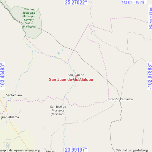
San Juan de Guadalupe GPS coordinates[2]
24° 37' 57.828" North, 102° 46' 54.48" West
| Map corner | latitude | longitude |
|---|---|---|
| Upper-left | 25.27022°, | -103.48493° |
| Center: | 24.63273°, | -102.7818° |
| Lower-right: | 23.99197°, | -102.07868° |
| Map W x H: | 142.1×142.1 km | = 88.3×88.3mi |
| max Lat: | 32.7° ⇑8.9% North |
| San Juan de Guadalupe: | 24.63273° |
| min Lat: | ⇓91.1% South 14.53588° |
| min Long | San Juan de Gua | max Long |
| -117.105° | -102.7818° | -86.73105° |
| W 14.9%⇐ | ⇒85.1% E |
Elevation
Elevation of San Juan de Guadalupe is 1529 m = 5016 ft, and this is 275.3 m = 903 ft above average elevation for this country.
| Max E: |
3497 m = 11473 ft | 47.7% |
| San Juan de Guadalupe | 1529 m 5016 ft | |
| Avg. | 1253.7 m = 4113 ft | |
Min E: |
-1 m = -3 ft | 52.3% |
See also: Mexico elevation on elevation.city.
Geographical zone
San Juan de Guadalupe is located in North temperate zone (between Tropic of Cancer and the Arctic Circle). Distance of this Northern Tropic circle is 133 km =82.6 mi to South.| Distance of | km | miles | from San Juan de Guadalupe |
|---|---|---|---|
| North Pole | 7268.2 | 4516.2 | to North |
| Arctic Circle | 4662.3 | 2897 | to North |
| Tropic Cancer | 133 | 82.6 | to South |
| Equator | 2738.9 | 1701.9 | to South |


Nearby cities:
15 places around San Juan de Guadalupe: (largest is in red/bold)
• Apizolaya
54.9 km =34.1 mi,  68°
68°
• Caopas
63.6 km =39.5 mi, 74°
• Estación Camacho
46.6 km =29 mi,  117°
117°
• General Simón Bolívar
45.3 km =28.1 mi,  277°
277°
• José Isabel Robles
51.8 km =32.2 mi,  271°
271°
• La Laguna
61.8 km =38.4 mi,  221°
221°
• Las Norias (Norias)
38.3 km =23.8 mi,  167°
167°
• Luis Moya
57.8 km =35.9 mi,  191°
191°
• Ojitos
67.5 km =41.9 mi,  237°
237°
• Oriente Aguanaval
54.6 km =33.9 mi,  303°
303°
• San Jose de Reyes
41.2 km =25.6 mi, 238°
• San José de Morteros
35.7 km =22.2 mi,  207°
207°
• San Lucas de Abajo
58.7 km =36.5 mi, 213°
• Santa Clara
60.8 km =37.8 mi,  253°
253°
• Villa Cardenas
50.2 km =31.2 mi, 220°
Sources, notices
• [Note1] Compared only with cities in Mexico existing in our database
• [Src1] Map data: © OpenStreetMap contributors (CC-BY-SA)
• [Src2] Other city data from geonames.org with taken over terms of usage.
• [Src3] Geographical zone / Annual Mean Temperature by Robert A. Rohde @ Wikipedia
