San Antonio la D geodata
San Antonio la D (Querétaro) is a populated place; located in Mexico in America/Mexico_City (GMT-6) time zone. With population of 665 people, there are 13061 cities with bigger population in this country. Compared to other cities in Mexico, 66.1% of cities are located further ↓South; 66% of cities are located further →East and 74.1% of cities have lower elevation than San Antonio la D. Note1


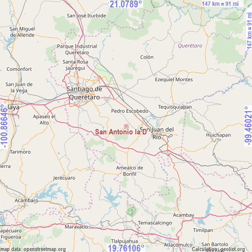
San Antonio la D GPS coordinates[2]
20° 25' 17.004" North, 100° 9' 47.988" West
| Map corner | latitude | longitude |
|---|---|---|
| Upper-left | 21.0789°, | -100.86646° |
| Center: | 20.42139°, | -100.16333° |
| Lower-right: | 19.76106°, | -99.46021° |
| Map W x H: | 146.5×146.5 km | = 91×91mi |
| max Lat: | 32.7° ⇑33.9% North |
| San Antonio la D: | 20.42139° |
| min Lat: | ⇓66.1% South 14.53588° |
| min Long | San Antonio la | max Long |
| -117.105° | -100.16333° | -86.73105° |
| W 34%⇐ | ⇒66% E |
Elevation
Elevation of San Antonio la D is 2015 m = 6611 ft, and this is 761.3 m = 2498 ft above average elevation for this country.
| Max E: |
3497 m = 11473 ft | 25.9% |
| San Antonio la D | 2015 m 6611 ft | |
| Avg. | 1253.7 m = 4113 ft | |
Min E: |
-1 m = -3 ft | 74.1% |
See also: Mexico elevation on elevation.city.
Geographical zone
San Antonio la D is located in North Torrid zone (between Equator and Tropic of Cancer). Distance of this Northern Tropic circle is 335.3 km =208.3 mi to North.| Distance of | km | miles | from San Antonio la D |
|---|---|---|---|
| North Pole | 7736.4 | 4807.2 | to North |
| Arctic Circle | 5130.5 | 3187.9 | to North |
| Tropic Cancer | 335.3 | 208.3 | to North |
| Equator | 2270.6 | 1410.9 | to South |


Nearby cities:
15 places around San Antonio la D: (largest is in red/bold)
• Ajuchitlancito
8.2 km =5.1 mi,  317°
317°
• Arcila
5.7 km =3.5 mi,  102°
102°
• El Coto
4.2 km =2.6 mi,  134°
134°
• El Rosario
10.7 km =6.6 mi,  107°
107°
• El Saúz
8 km =5 mi,  38°
38°
• Escolasticas
5.1 km =3.2 mi,  278°
278°
• Galindo
7.3 km =4.5 mi, 111°
• La D
2.4 km =1.5 mi,  27°
27°
• La Estancia
10.1 km =6.3 mi,  90°
90°
• La Lira
6 km =3.7 mi,  1°
1°
• Laguna de Vaquerías
8.1 km =5 mi,  158°
158°
• Pedro Escobedo
9 km =5.6 mi,  13°
13°
• Puerta de Alegrías
9.8 km =6.1 mi,  141°
141°
• San Cirilo
4.1 km =2.5 mi,  256°
256°
• Vaquerías
8.5 km =5.3 mi,  147°
147°
Sources, notices
• [Note1] Compared only with cities in Mexico existing in our database
• [Src1] Map data: © OpenStreetMap contributors (CC-BY-SA)
• [Src2] Other city data from geonames.org with taken over terms of usage.
• [Src3] Geographical zone / Annual Mean Temperature by Robert A. Rohde @ Wikipedia
