La D geodata
La D (Querétaro) is a populated place; located in Mexico in America/Mexico_City (GMT-6) time zone. With population of 4,298 people, there are 2133 cities with bigger population in this country. Compared to other cities in Mexico, 66.5% of cities are located further ↓South; 65.9% of cities are located further →East and 71.7% of cities have lower elevation than La D. Note1


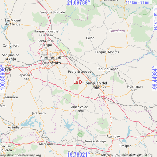
La D GPS coordinates[2]
20° 26' 25.656" North, 100° 9' 10.656" West
| Map corner | latitude | longitude |
|---|---|---|
| Upper-left | 21.09789°, | -100.85609° |
| Center: | 20.44046°, | -100.15296° |
| Lower-right: | 19.78021°, | -99.44984° |
| Map W x H: | 146.5×146.5 km | = 91×91mi |
| max Lat: | 32.7° ⇑33.5% North |
| La D: | 20.44046° |
| min Lat: | ⇓66.5% South 14.53588° |
| min Long | La D | max Long |
| -117.105° | -100.15296° | -86.73105° |
| W 34.1%⇐ | ⇒65.9% E |
Elevation
Elevation of La D is 1962 m = 6437 ft, and this is 708.3 m = 2324 ft above average elevation for this country.
| Max E: |
3497 m = 11473 ft | 28.3% |
| La D | 1962 m 6437 ft | |
| Avg. | 1253.7 m = 4113 ft | |
Min E: |
-1 m = -3 ft | 71.7% |
See also: Mexico elevation on elevation.city.
Geographical zone
La D is located in North Torrid zone (between Equator and Tropic of Cancer). Distance of this Northern Tropic circle is 333.2 km =207 mi to North.| Distance of | km | miles | from La D |
|---|---|---|---|
| North Pole | 7734.3 | 4805.9 | to North |
| Arctic Circle | 5128.4 | 3186.6 | to North |
| Tropic Cancer | 333.2 | 207 | to North |
| Equator | 2272.8 | 1412.3 | to South |


Nearby cities:
15 places around La D: (largest is in red/bold)
• Ajuchitlancito
7.6 km =4.7 mi,  301°
301°
• Arcila
5.6 km =3.5 mi,  126°
126°
• El Coto
5.4 km =3.4 mi,  159°
159°
• El Saúz
5.7 km =3.5 mi,  43°
43°
• Escolasticas
6.3 km =3.9 mi,  257°
257°
• Galindo
7.4 km =4.6 mi, 130°
• La Estancia
9.3 km =5.8 mi,  103°
103°
• La Lira
4 km =2.5 mi,  347°
347°
• La Palma
9.3 km =5.8 mi, 346°
• Laguna de Vaquerías
9.8 km =6.1 mi,  169°
169°
• Pedro Escobedo
6.7 km =4.2 mi,  9°
9°
• Quintanares
9.6 km =6 mi, 9°
• San Antonio la D
2.4 km =1.5 mi,  207°
207°
• San Cirilo
5.9 km =3.7 mi,  239°
239°
• San Javier
9.6 km =6 mi,  80°
80°
Sources, notices
• [Note1] Compared only with cities in Mexico existing in our database
• [Src1] Map data: © OpenStreetMap contributors (CC-BY-SA)
• [Src2] Other city data from geonames.org with taken over terms of usage.
• [Src3] Geographical zone / Annual Mean Temperature by Robert A. Rohde @ Wikipedia
