Galeras geodata
Galeras (Querétaro) is a populated place; located in Mexico in America/Mexico_City (GMT-6) time zone. With population of 2,358 people, there are 3746 cities with bigger population in this country. Compared to other cities in Mexico, 70.3% of cities are located further ↓South; 66% of cities are located further →East and 69.8% of cities have lower elevation than Galeras. Note1


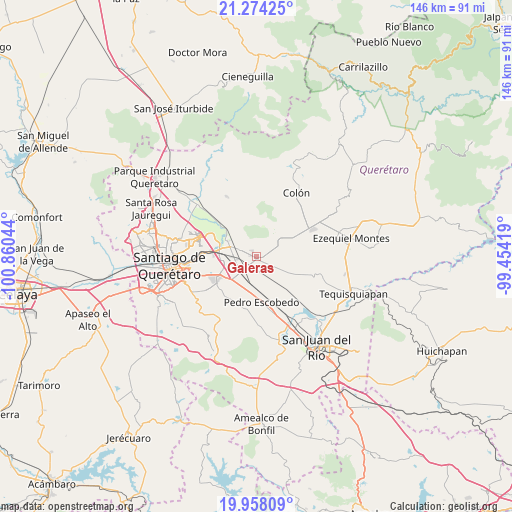
Galeras GPS coordinates[2]
20° 37' 3.324" North, 100° 9' 26.316" West
| Map corner | latitude | longitude |
|---|---|---|
| Upper-left | 21.27425°, | -100.86044° |
| Center: | 20.61759°, | -100.15731° |
| Lower-right: | 19.95809°, | -99.45419° |
| Map W x H: | 146.3×146.3 km | = 90.9×90.9mi |
| max Lat: | 32.7° ⇑29.7% North |
| Galeras: | 20.61759° |
| min Lat: | ⇓70.3% South 14.53588° |
| min Long | Galeras | max Long |
| -117.105° | -100.15731° | -86.73105° |
| W 34%⇐ | ⇒66% E |
Elevation
Elevation of Galeras is 1920 m = 6299 ft, and this is 666.3 m = 2186 ft above average elevation for this country.
| Max E: |
3497 m = 11473 ft | 30.2% |
| Galeras | 1920 m 6299 ft | |
| Avg. | 1253.7 m = 4113 ft | |
Min E: |
-1 m = -3 ft | 69.8% |
See also: Mexico elevation on elevation.city.
Geographical zone
Galeras is located in North Torrid zone (between Equator and Tropic of Cancer). Distance of this Northern Tropic circle is 313.5 km =194.8 mi to North.| Distance of | km | miles | from Galeras |
|---|---|---|---|
| North Pole | 7714.6 | 4793.6 | to North |
| Arctic Circle | 5108.7 | 3174.4 | to North |
| Tropic Cancer | 313.5 | 194.8 | to North |
| Equator | 2292.5 | 1424.5 | to South |


Nearby cities:
15 places around Galeras: (largest is in red/bold)
• Agua Azul
5.2 km =3.2 mi,  251°
251°
• Calamanda
8.4 km =5.2 mi,  200°
200°
• Coyotillos
5.7 km =3.5 mi, 249°
• El Blanco
5.8 km =3.6 mi,  96°
96°
• Epigmenio González
7.5 km =4.7 mi,  186°
186°
• Esperanza
5.7 km =3.5 mi,  56°
56°
• Guadalupe la Venta
7.3 km =4.5 mi,  294°
294°
• Los Álvarez
7.5 km =4.7 mi,  166°
166°
• México Lindo
6.9 km =4.3 mi,  128°
128°
• Noria Nueva
7.6 km =4.7 mi,  153°
153°
• Purísima de Cubos (La Purísima)
4.5 km =2.8 mi,  115°
115°
• San Francisco
4.7 km =2.9 mi, 149°
• San Ildefonso
5.8 km =3.6 mi, 195°
• San Vicente el Alto
5.5 km =3.4 mi, 188°
• Viborillas
3.1 km =1.9 mi, 251°
Sources, notices
• [Note1] Compared only with cities in Mexico existing in our database
• [Src1] Map data: © OpenStreetMap contributors (CC-BY-SA)
• [Src2] Other city data from geonames.org with taken over terms of usage.
• [Src3] Geographical zone / Annual Mean Temperature by Robert A. Rohde @ Wikipedia
