Los Álvarez geodata
Los Álvarez (Querétaro) is a populated place; located in Mexico in America/Mexico_City (GMT-6) time zone. With population of 917 people, there are 9514 cities with bigger population in this country. Compared to other cities in Mexico, 68.9% of cities are located further ↓South; 65.7% of cities are located further →East and 69.2% of cities have lower elevation than Los Álvarez. Note1


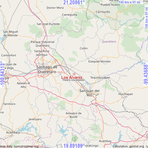
Los Álvarez GPS coordinates[2]
20° 33' 6.012" North, 100° 8' 24" West
| Map corner | latitude | longitude |
|---|---|---|
| Upper-left | 21.20861°, | -100.84313° |
| Center: | 20.55167°, | -100.14° |
| Lower-right: | 19.89189°, | -99.43688° |
| Map W x H: | 146.4×146.4 km | = 91×91mi |
| max Lat: | 32.7° ⇑31.1% North |
| Los Álvarez: | 20.55167° |
| min Lat: | ⇓68.9% South 14.53588° |
| min Long | Los Álvarez | max Long |
| -117.105° | -100.14° | -86.73105° |
| W 34.3%⇐ | ⇒65.7% E |
Elevation
Elevation of Los Álvarez is 1911 m = 6270 ft, and this is 657.3 m = 2156 ft above average elevation for this country.
| Max E: |
3497 m = 11473 ft | 30.8% |
| Los Álvarez | 1911 m 6270 ft | |
| Avg. | 1253.7 m = 4113 ft | |
Min E: |
-1 m = -3 ft | 69.2% |
See also: Mexico elevation on elevation.city.
Geographical zone
Los Álvarez is located in North Torrid zone (between Equator and Tropic of Cancer). Distance of this Northern Tropic circle is 320.8 km =199.3 mi to North.| Distance of | km | miles | from Los Álvarez |
|---|---|---|---|
| North Pole | 7721.9 | 4798.2 | to North |
| Arctic Circle | 5116 | 3178.9 | to North |
| Tropic Cancer | 320.8 | 199.3 | to North |
| Equator | 2285.1 | 1419.9 | to South |


Nearby cities:
15 places around Los Álvarez: (largest is in red/bold)
• Calamanda
4.8 km =3 mi,  263°
263°
• Epigmenio González
2.6 km =1.6 mi,  268°
268°
• Galeras
7.5 km =4.7 mi,  346°
346°
• Guadalupe Septién
3.9 km =2.4 mi,  134°
134°
• Ignacio Pérez
4.4 km =2.7 mi,  137°
137°
• La Palma
4.8 km =3 mi,  227°
227°
• México Lindo
4.7 km =2.9 mi,  50°
50°
• Noria Nueva
1.7 km =1.1 mi,  70°
70°
• Pedro Escobedo
5.8 km =3.6 mi,  182°
182°
• Purísima de Cubos (La Purísima)
5.9 km =3.7 mi,  22°
22°
• Quintanares
2.9 km =1.8 mi, 176°
• San Clemente
7.1 km =4.4 mi, 125°
• San Francisco
3.4 km =2.1 mi,  9°
9°
• San Ildefonso
3.8 km =2.4 mi,  297°
297°
• San Vicente el Alto
3.2 km =2 mi,  305°
305°
Sources, notices
• [Note1] Compared only with cities in Mexico existing in our database
• [Src1] Map data: © OpenStreetMap contributors (CC-BY-SA)
• [Src2] Other city data from geonames.org with taken over terms of usage.
• [Src3] Geographical zone / Annual Mean Temperature by Robert A. Rohde @ Wikipedia
