Calamanda geodata
Calamanda (Querétaro) is a populated place; located in Mexico in America/Mexico_City (GMT-6) time zone. With population of 1,743 people, there are 4980 cities with bigger population in this country. Compared to other cities in Mexico, 68.8% of cities are located further ↓South; 66.3% of cities are located further →East and 69.5% of cities have lower elevation than Calamanda. Note1


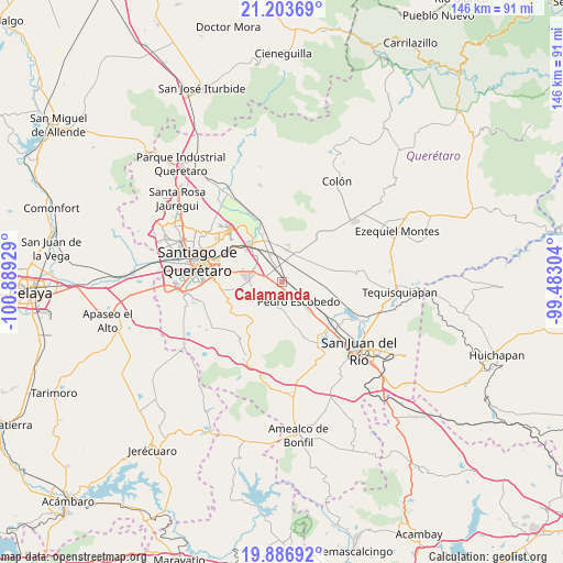
Calamanda GPS coordinates[2]
20° 32' 48.192" North, 100° 11' 10.176" West
| Map corner | latitude | longitude |
|---|---|---|
| Upper-left | 21.20369°, | -100.88929° |
| Center: | 20.54672°, | -100.18616° |
| Lower-right: | 19.88692°, | -99.48304° |
| Map W x H: | 146.4×146.4 km | = 91×91mi |
| max Lat: | 32.7° ⇑31.2% North |
| Calamanda: | 20.54672° |
| min Lat: | ⇓68.8% South 14.53588° |
| min Long | Calamanda | max Long |
| -117.105° | -100.18616° | -86.73105° |
| W 33.7%⇐ | ⇒66.3% E |
Elevation
Elevation of Calamanda is 1915 m = 6283 ft, and this is 661.3 m = 2170 ft above average elevation for this country.
| Max E: |
3497 m = 11473 ft | 30.5% |
| Calamanda | 1915 m 6283 ft | |
| Avg. | 1253.7 m = 4113 ft | |
Min E: |
-1 m = -3 ft | 69.5% |
See also: Mexico elevation on elevation.city.
Geographical zone
Calamanda is located in North Torrid zone (between Equator and Tropic of Cancer). Distance of this Northern Tropic circle is 321.3 km =199.6 mi to North.| Distance of | km | miles | from Calamanda |
|---|---|---|---|
| North Pole | 7722.5 | 4798.5 | to North |
| Arctic Circle | 5116.6 | 3179.3 | to North |
| Tropic Cancer | 321.3 | 199.6 | to North |
| Equator | 2284.6 | 1419.6 | to South |


Nearby cities:
15 places around Calamanda: (largest is in red/bold)
• Agua Azul
6.5 km =4 mi,  342°
342°
• Coyotillos
6.3 km =3.9 mi, 337°
• El Colorado
6.4 km =4 mi,  285°
285°
• El Paraíso
3.7 km =2.3 mi,  301°
301°
• Epigmenio González
2.2 km =1.4 mi,  78°
78°
• General Lázaro Cárdenas (El Colorado)
6.3 km =3.9 mi, 287°
• La Palma
3 km =1.9 mi,  154°
154°
• Los Álvarez
4.8 km =3 mi, 83°
• Noria Nueva
6.5 km =4 mi, 80°
• Palo Alto
3.7 km =2.3 mi,  259°
259°
• Quintanares
5.5 km =3.4 mi,  115°
115°
• San Antonio la Galera
6 km =3.7 mi,  245°
245°
• San Francisco
6.6 km =4.1 mi,  54°
54°
• San Ildefonso
2.7 km =1.7 mi,  31°
31°
• San Vicente el Alto
3.3 km =2.1 mi,  42°
42°
Sources, notices
• [Note1] Compared only with cities in Mexico existing in our database
• [Src1] Map data: © OpenStreetMap contributors (CC-BY-SA)
• [Src2] Other city data from geonames.org with taken over terms of usage.
• [Src3] Geographical zone / Annual Mean Temperature by Robert A. Rohde @ Wikipedia
