El Verde geodata
El Verde (Jalisco) is a populated place; located in Mexico in America/Mexico_City (GMT-6) time zone. With population of 7,556 people, there are 1235 cities with bigger population in this country. Compared to other cities in Mexico, 69% of cities are located further ↓South; 87% of cities are located further →East and 53% of cities have lower elevation than El Verde. Note1


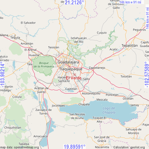
El Verde GPS coordinates[2]
20° 33' 20.412" North, 103° 16' 44.436" West
| Map corner | latitude | longitude |
|---|---|---|
| Upper-left | 21.2126°, | -103.98214° |
| Center: | 20.55567°, | -103.27901° |
| Lower-right: | 19.89591°, | -102.57589° |
| Map W x H: | 146.4×146.4 km | = 91×91mi |
| max Lat: | 32.7° ⇑31% North |
| El Verde: | 20.55567° |
| min Lat: | ⇓69% South 14.53588° |
| min Long | El Verde | max Long |
| -117.105° | -103.27901° | -86.73105° |
| W 13%⇐ | ⇒87% E |
Elevation
Elevation of El Verde is 1542 m = 5059 ft, and this is 288.3 m = 946 ft above average elevation for this country.
| Max E: |
3497 m = 11473 ft | 47% |
| El Verde | 1542 m 5059 ft | |
| Avg. | 1253.7 m = 4113 ft | |
Min E: |
-1 m = -3 ft | 53% |
See also: Mexico elevation on elevation.city.
Geographical zone
El Verde is located in North Torrid zone (between Equator and Tropic of Cancer). Distance of this Northern Tropic circle is 320.3 km =199 mi to North.| Distance of | km | miles | from El Verde |
|---|---|---|---|
| North Pole | 7721.5 | 4797.9 | to North |
| Arctic Circle | 5115.6 | 3178.7 | to North |
| Tropic Cancer | 320.3 | 199 | to North |
| Equator | 2285.6 | 1420.2 | to South |


Nearby cities:
15 places around El Verde: (largest is in red/bold)
• Capulín
8.7 km =5.4 mi,  173°
173°
• Colonia Guadalupana
6.4 km =4 mi,  78°
78°
• El Mirador
2.3 km =1.4 mi,  15°
15°
• El Muey
8.4 km =5.2 mi,  134°
134°
• El Quince
1.4 km =0.9 mi,  204°
204°
• El Refugio
3.3 km =2.1 mi, 197°
• Hacienda Vieja del Castillo (Castillo Viejo)
4 km =2.5 mi,  115°
115°
• La Alameda
7.4 km =4.6 mi,  154°
154°
• La Punta
7.2 km =4.5 mi, 75°
• Las Pintas de Arriba
5 km =3.1 mi,  293°
293°
• Las Pintitas
2.6 km =1.6 mi, 291°
• Los Amiales
8.2 km =5.1 mi,  37°
37°
• Paseos del Valle [Fraccionamiento]
6.8 km =4.2 mi,  236°
236°
• San José del Castillo
6.3 km =3.9 mi,  137°
137°
• Sendero Real
8.2 km =5.1 mi,  247°
247°
Sources, notices
• [Note1] Compared only with cities in Mexico existing in our database
• [Src1] Map data: © OpenStreetMap contributors (CC-BY-SA)
• [Src2] Other city data from geonames.org with taken over terms of usage.
• [Src3] Geographical zone / Annual Mean Temperature by Robert A. Rohde @ Wikipedia
