El Quince geodata
El Quince (Jalisco) is a populated place; located in Mexico in America/Mexico_City (GMT-6) time zone. With population of 17,669 people, there are 548 cities with bigger population in this country. Compared to other cities in Mexico, 68.7% of cities are located further ↓South; 87.1% of cities are located further →East and 52% of cities have lower elevation than El Quince. Note1


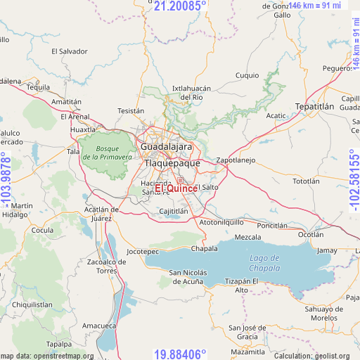
El Quince GPS coordinates[2]
20° 32' 37.932" North, 103° 17' 4.812" West
| Map corner | latitude | longitude |
|---|---|---|
| Upper-left | 21.20085°, | -103.9878° |
| Center: | 20.54387°, | -103.28467° |
| Lower-right: | 19.88406°, | -102.58155° |
| Map W x H: | 146.4×146.4 km | = 91×91mi |
| max Lat: | 32.7° ⇑31.3% North |
| El Quince: | 20.54387° |
| min Lat: | ⇓68.7% South 14.53588° |
| min Long | El Quince | max Long |
| -117.105° | -103.28467° | -86.73105° |
| W 12.9%⇐ | ⇒87.1% E |
Elevation
Elevation of El Quince is 1525 m = 5003 ft, and this is 271.3 m = 890 ft above average elevation for this country.
| Max E: |
3497 m = 11473 ft | 48% |
| El Quince | 1525 m 5003 ft | |
| Avg. | 1253.7 m = 4113 ft | |
Min E: |
-1 m = -3 ft | 52% |
See also: Mexico elevation on elevation.city.
Geographical zone
El Quince is located in North Torrid zone (between Equator and Tropic of Cancer). Distance of this Northern Tropic circle is 321.7 km =199.9 mi to North.| Distance of | km | miles | from El Quince |
|---|---|---|---|
| North Pole | 7722.8 | 4798.7 | to North |
| Arctic Circle | 5116.9 | 3179.5 | to North |
| Tropic Cancer | 321.7 | 199.9 | to North |
| Equator | 2284.3 | 1419.4 | to South |


Nearby cities:
15 places around El Quince: (largest is in red/bold)
• Capulín
7.5 km =4.7 mi,  167°
167°
• Colonia Guadalupana
7.3 km =4.5 mi,  69°
69°
• El Mirador
3.8 km =2.4 mi,  18°
18°
• El Muey
8.1 km =5 mi,  124°
124°
• El Refugio
1.9 km =1.2 mi,  192°
192°
• El Verde
1.4 km =0.9 mi, 24°
• Hacienda Vieja del Castillo (Castillo Viejo)
4.2 km =2.6 mi,  95°
95°
• Jardines del Edén
8.2 km =5.1 mi,  261°
261°
• La Alameda
6.6 km =4.1 mi,  144°
144°
• La Punta
8.2 km =5.1 mi, 68°
• Las Pintas de Arriba
5.2 km =3.2 mi,  309°
309°
• Las Pintitas
2.9 km =1.8 mi,  321°
321°
• Paseos del Valle [Fraccionamiento]
5.6 km =3.5 mi,  244°
244°
• San José del Castillo
5.9 km =3.7 mi, 124°
• Sendero Real
7.2 km =4.5 mi, 255°
Sources, notices
• [Note1] Compared only with cities in Mexico existing in our database
• [Src1] Map data: © OpenStreetMap contributors (CC-BY-SA)
• [Src2] Other city data from geonames.org with taken over terms of usage.
• [Src3] Geographical zone / Annual Mean Temperature by Robert A. Rohde @ Wikipedia
