El Refugio geodata
El Refugio (Jalisco) is a populated place; located in Mexico in America/Mexico_City (GMT-6) time zone. With population of 869 people, there are 10053 cities with bigger population in this country. Compared to other cities in Mexico, 68.4% of cities are located further ↓South; 87.1% of cities are located further →East and 52% of cities have lower elevation than El Refugio. Note1


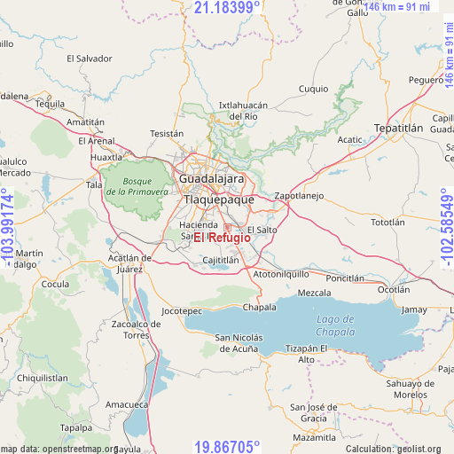
El Refugio GPS coordinates[2]
20° 31' 36.984" North, 103° 17' 18.996" West
| Map corner | latitude | longitude |
|---|---|---|
| Upper-left | 21.18399°, | -103.99174° |
| Center: | 20.52694°, | -103.28861° |
| Lower-right: | 19.86705°, | -102.58549° |
| Map W x H: | 146.4×146.4 km | = 91×91mi |
| max Lat: | 32.7° ⇑31.6% North |
| El Refugio: | 20.52694° |
| min Lat: | ⇓68.4% South 14.53588° |
| min Long | El Refugio | max Long |
| -117.105° | -103.28861° | -86.73105° |
| W 12.9%⇐ | ⇒87.1% E |
Elevation
Elevation of El Refugio is 1525 m = 5003 ft, and this is 271.3 m = 890 ft above average elevation for this country.
| Max E: |
3497 m = 11473 ft | 48% |
| El Refugio | 1525 m 5003 ft | |
| Avg. | 1253.7 m = 4113 ft | |
Min E: |
-1 m = -3 ft | 52% |
See also: Mexico elevation on elevation.city.
Geographical zone
El Refugio is located in North Torrid zone (between Equator and Tropic of Cancer). Distance of this Northern Tropic circle is 323.5 km =201 mi to North.| Distance of | km | miles | from El Refugio |
|---|---|---|---|
| North Pole | 7724.7 | 4799.9 | to North |
| Arctic Circle | 5118.8 | 3180.7 | to North |
| Tropic Cancer | 323.5 | 201 | to North |
| Equator | 2282.4 | 1418.2 | to South |


Nearby cities:
15 places around El Refugio: (largest is in red/bold)
• Capulín
5.8 km =3.6 mi,  159°
159°
• El Mirador
5.7 km =3.5 mi,  16°
16°
• El Muey
7.6 km =4.7 mi,  110°
110°
• El Quince
1.9 km =1.2 mi,  12°
12°
• El Verde
3.3 km =2.1 mi, 17°
• Hacienda Vieja del Castillo (Castillo Viejo)
4.8 km =3 mi,  72°
72°
• Jardines del Edén
7.7 km =4.8 mi,  274°
274°
• La Alameda
5.5 km =3.4 mi,  130°
130°
• Las Pintas de Arriba
6.3 km =3.9 mi,  325°
325°
• Las Pintitas
4.4 km =2.7 mi,  341°
341°
• Paseos del Valle [Fraccionamiento]
4.7 km =2.9 mi,  263°
263°
• Rancho Alegre [Fraccionamiento]
6.7 km =4.2 mi,  151°
151°
• San José del Castillo
5.5 km =3.4 mi, 105°
• Sendero Real
6.6 km =4.1 mi, 271°
• Valle Dorado Inn
7.6 km =4.7 mi, 267°
Sources, notices
• [Note1] Compared only with cities in Mexico existing in our database
• [Src1] Map data: © OpenStreetMap contributors (CC-BY-SA)
• [Src2] Other city data from geonames.org with taken over terms of usage.
• [Src3] Geographical zone / Annual Mean Temperature by Robert A. Rohde @ Wikipedia
