El Salvador geodata
El Salvador (Jalisco) is a populated place; located in Mexico in America/Mexico_City (GMT-6) time zone. With population of 2,502 people, there are 3531 cities with bigger population in this country. Compared to other cities in Mexico, 76.7% of cities are located further ↓South; 89.1% of cities are located further →East and 65.2% of cities have lower elevation than El Salvador. Note1


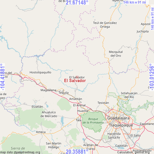
El Salvador GPS coordinates[2]
21° 0' 59.724" North, 103° 42' 56.448" West
| Map corner | latitude | longitude |
|---|---|---|
| Upper-left | 21.67148°, | -104.41881° |
| Center: | 21.01659°, | -103.71568° |
| Lower-right: | 20.35881°, | -103.01256° |
| Map W x H: | 146×146 km | = 90.7×90.7mi |
| max Lat: | 32.7° ⇑23.3% North |
| El Salvador: | 21.01659° |
| min Lat: | ⇓76.7% South 14.53588° |
| min Long | El Salvador | max Long |
| -117.105° | -103.71568° | -86.73105° |
| W 10.9%⇐ | ⇒89.1% E |
Elevation
Elevation of El Salvador is 1834 m = 6017 ft, and this is 580.3 m = 1904 ft above average elevation for this country.
| Max E: |
3497 m = 11473 ft | 34.8% |
| El Salvador | 1834 m 6017 ft | |
| Avg. | 1253.7 m = 4113 ft | |
Min E: |
-1 m = -3 ft | 65.2% |
See also: Mexico elevation on elevation.city.
Geographical zone
El Salvador is located in North Torrid zone (between Equator and Tropic of Cancer). Distance of this Northern Tropic circle is 269.1 km =167.2 mi to North.| Distance of | km | miles | from El Salvador |
|---|---|---|---|
| North Pole | 7670.2 | 4766 | to North |
| Arctic Circle | 5064.3 | 3146.8 | to North |
| Tropic Cancer | 269.1 | 167.2 | to North |
| Equator | 2336.8 | 1452 | to South |


Nearby cities:
15 places around El Salvador: (largest is in red/bold)
• Amatitán
20.4 km =12.7 mi,  184°
184°
• Colonia Cuisillos (Huaxtla de Orendain)
33.1 km =20.6 mi,  169°
169°
• El Arenal
26.9 km =16.7 mi, 175°
• El Llano de los Vela
20.8 km =12.9 mi,  264°
264°
• El Medineño
17.9 km =11.1 mi,  201°
201°
• Huaxtla
32.1 km =19.9 mi, 170°
• Huitzila
25.6 km =15.9 mi,  26°
26°
• Magdalena
29.8 km =18.5 mi,  245°
245°
• San Cristóbal de la Barranca
30 km =18.6 mi,  84°
84°
• San Martín de las Cañas
16.7 km =10.4 mi,  241°
241°
• San Simón
30.8 km =19.1 mi, 264°
• Santa Cruz del Astillero
31 km =19.3 mi, 165°
• Santa Teresa
21.5 km =13.4 mi, 238°
• Santiaguito
26.3 km =16.3 mi, 181°
• Tequila
19.5 km =12.1 mi,  219°
219°
Sources, notices
• [Note1] Compared only with cities in Mexico existing in our database
• [Src1] Map data: © OpenStreetMap contributors (CC-BY-SA)
• [Src2] Other city data from geonames.org with taken over terms of usage.
• [Src3] Geographical zone / Annual Mean Temperature by Robert A. Rohde @ Wikipedia
