Amatitán geodata
Amatitán (Jalisco) is a seat of a second-order administrative division; located in Mexico in America/Mexico_City (GMT-6) time zone. With population of 11,006 people, there are 863 cities with bigger population in this country. Compared to other cities in Mexico, 73.8% of cities are located further ↓South; 89.2% of cities are located further →East and 53.9% of cities have higher elevation than Amatitán. Note1


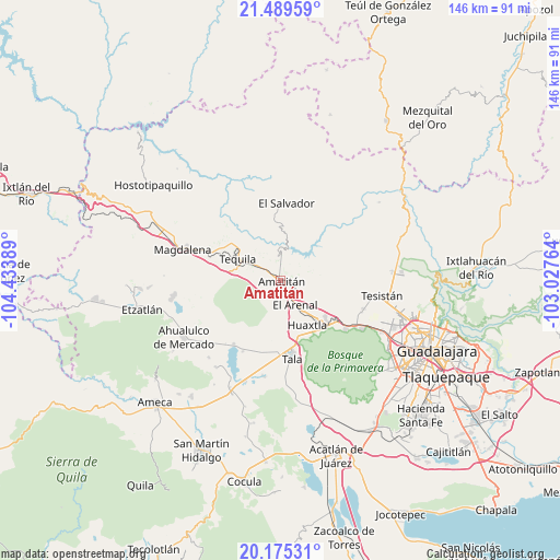
Amatitán GPS coordinates[2]
20° 50' 1.968" North, 103° 43' 50.736" West
| Map corner | latitude | longitude |
|---|---|---|
| Upper-left | 21.48959°, | -104.43389° |
| Center: | 20.83388°, | -103.73076° |
| Lower-right: | 20.17531°, | -103.02764° |
| Map W x H: | 146.1×146.1 km | = 90.8×90.8mi |
| max Lat: | 32.7° ⇑26.2% North |
| Amatitán: | 20.83388° |
| min Lat: | ⇓73.8% South 14.53588° |
| min Long | Amatitán | max Long |
| -117.105° | -103.73076° | -86.73105° |
| W 10.8%⇐ | ⇒89.2% E |
Elevation
Elevation of Amatitán is 1251 m = 4104 ft, and this is 2.7 m = 9 ft below average elevation for this country.
| Max E: |
3497 m = 11473 ft | 53.9% |
| Avg. | 1253.7 m = 4113 ft | |
| Amatitán | 1251 m = 4104 ft | |
Min E: |
-1 m = -3 ft | 46.1% |
See also: Mexico elevation on elevation.city.
Geographical zone
Amatitán is located in North Torrid zone (between Equator and Tropic of Cancer). Distance of this Northern Tropic circle is 289.4 km =179.8 mi to North.| Distance of | km | miles | from Amatitán |
|---|---|---|---|
| North Pole | 7690.6 | 4778.7 | to North |
| Arctic Circle | 5084.7 | 3159.5 | to North |
| Tropic Cancer | 289.4 | 179.8 | to North |
| Equator | 2316.5 | 1439.4 | to South |


Nearby cities:
15 places around Amatitán: (largest is in red/bold)
• Colonia Cuisillos (Huaxtla de Orendain)
14.5 km =9 mi,  147°
147°
• El Arenal
7.6 km =4.7 mi, 149°
• El Medineño
6.2 km =3.9 mi,  306°
306°
• El Refugio
18.1 km =11.2 mi,  182°
182°
• El Salvador
20.4 km =12.7 mi,  4°
4°
• Huaxtla
13.4 km =8.3 mi, 148°
• La Estanzuela
20.8 km =12.9 mi,  208°
208°
• Los Ruiseñores
14.3 km =8.9 mi,  163°
163°
• San Martín de las Cañas
18.1 km =11.2 mi, 313°
• Santa Cruz del Astillero
13.3 km =8.3 mi,  136°
136°
• Santa Teresa
19.1 km =11.9 mi,  298°
298°
• Santiaguito
6 km =3.7 mi,  173°
173°
• Tala
20.3 km =12.6 mi, 171°
• Tequila
12.2 km =7.6 mi, 296°
• Teuchitlán
20.7 km =12.9 mi,  216°
216°
Sources, notices
• [Note1] Compared only with cities in Mexico existing in our database
• [Src1] Map data: © OpenStreetMap contributors (CC-BY-SA)
• [Src2] Other city data from geonames.org with taken over terms of usage.
• [Src3] Geographical zone / Annual Mean Temperature by Robert A. Rohde @ Wikipedia
