Tequila geodata
Tequila (Jalisco) is a seat of a second-order administrative division; located in Mexico in America/Mexico_City (GMT-6) time zone. With population of 29,203 people, there are 342 cities with bigger population in this country. Compared to other cities in Mexico, 74.5% of cities are located further ↓South; 89.5% of cities are located further →East and 55% of cities have higher elevation than Tequila. Note1


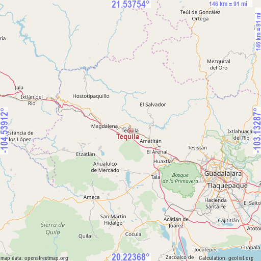
Tequila GPS coordinates[2]
20° 52' 55.38" North, 103° 50' 9.564" West
| Map corner | latitude | longitude |
|---|---|---|
| Upper-left | 21.53754°, | -104.53912° |
| Center: | 20.88205°, | -103.83599° |
| Lower-right: | 20.22368°, | -103.13287° |
| Map W x H: | 146.1×146.1 km | = 90.8×90.8mi |
| max Lat: | 32.7° ⇑25.5% North |
| Tequila: | 20.88205° |
| min Lat: | ⇓74.5% South 14.53588° |
| min Long | Tequila | max Long |
| -117.105° | -103.83599° | -86.73105° |
| W 10.5%⇐ | ⇒89.5% E |
Elevation
Elevation of Tequila is 1197 m = 3927 ft, and this is 56.7 m = 186 ft below average elevation for this country.
| Max E: |
3497 m = 11473 ft | 55% |
| Avg. | 1253.7 m = 4113 ft | |
| Tequila | 1197 m = 3927 ft | |
Min E: |
-1 m = -3 ft | 45% |
See also: Mexico elevation on elevation.city.
Geographical zone
Tequila is located in North Torrid zone (between Equator and Tropic of Cancer). Distance of this Northern Tropic circle is 284.1 km =176.5 mi to North.| Distance of | km | miles | from Tequila |
|---|---|---|---|
| North Pole | 7685.2 | 4775.4 | to North |
| Arctic Circle | 5079.3 | 3156.1 | to North |
| Tropic Cancer | 284.1 | 176.5 | to North |
| Equator | 2321.9 | 1442.8 | to South |


Nearby cities:
15 places around Tequila: (largest is in red/bold)
• Amatitán
12.2 km =7.6 mi,  116°
116°
• Antonio Escobedo
20.9 km =13 mi,  244°
244°
• El Arenal
19 km =11.8 mi,  128°
128°
• El Llano de los Vela
15.5 km =9.6 mi,  328°
328°
• El Medineño
6.1 km =3.8 mi,  105°
105°
• El Salvador
19.5 km =12.1 mi,  39°
39°
• La Estancita
23.3 km =14.5 mi,  226°
226°
• La Joya
15.2 km =9.4 mi,  254°
254°
• Magdalena
15 km =9.3 mi,  280°
280°
• San Juanito de Escobedo
19.9 km =12.4 mi, 240°
• San Martín de las Cañas
7.5 km =4.7 mi,  342°
342°
• San Simón
21.7 km =13.5 mi,  303°
303°
• Santa Teresa
6.9 km =4.3 mi, 302°
• Santiaguito
16.3 km =10.1 mi, 134°
• Teuchitlán
22 km =13.7 mi,  183°
183°
Sources, notices
• [Note1] Compared only with cities in Mexico existing in our database
• [Src1] Map data: © OpenStreetMap contributors (CC-BY-SA)
• [Src2] Other city data from geonames.org with taken over terms of usage.
• [Src3] Geographical zone / Annual Mean Temperature by Robert A. Rohde @ Wikipedia
