El Recreo geodata
El Recreo (Sinaloa) is a populated place; located in Mexico in America/Mazatlan (GMT-7) time zone. With population of 579 people, there are 14804 cities with bigger population in this country. Compared to other cities in Mexico, 88.9% of cities are located further ↓South; 94.1% of cities are located further →East and 97% of cities have higher elevation than El Recreo. Note1


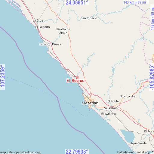
El Recreo GPS coordinates[2]
23° 26' 45.672" North, 106° 31' 57.972" West
| Map corner | latitude | longitude |
|---|---|---|
| Upper-left | 24.08951°, | -107.2359° |
| Center: | 23.44602°, | -106.53277° |
| Lower-right: | 22.79938°, | -105.82965° |
| Map W x H: | 143.4×143.4 km | = 89.1×89.1mi |
| max Lat: | 32.7° ⇑11.1% North |
| El Recreo: | 23.44602° |
| min Lat: | ⇓88.9% South 14.53588° |
| min Long | El Recreo | max Long |
| -117.105° | -106.53277° | -86.73105° |
| W 5.9%⇐ | ⇒94.1% E |
Elevation
Elevation of El Recreo is 10 m = 33 ft, and this is 1243.7 m = 4080 ft below average elevation for this country.
| Max E: |
3497 m = 11473 ft | 97% |
| Avg. | 1253.7 m = 4113 ft | |
| El Recreo | 10 m = 33 ft | |
Min E: |
-1 m = -3 ft | 3% |
See also: Mexico elevation on elevation.city.
Geographical zone
El Recreo is located in North temperate zone (between Tropic of Cancer and the Arctic Circle). Distance of this Northern Tropic circle is 1 km =0.6 mi to South.| Distance of | km | miles | from El Recreo |
|---|---|---|---|
| North Pole | 7400.1 | 4598.2 | to North |
| Arctic Circle | 4794.2 | 2979 | to North |
| Tropic Cancer | 1 | 0.6 | to South |
| Equator | 2607 | 1619.9 | to South |


Nearby cities:
15 places around El Recreo: (largest is in red/bold)
• El Bajío
35.6 km =22.1 mi,  115°
115°
• El Castillo
34.2 km =21.3 mi,  144°
144°
• El Habal
15.8 km =9.8 mi,  132°
132°
• El Quelite
14.2 km =8.8 mi,  27°
27°
• El Quemado
11.2 km =7 mi, 28°
• El Recodo
32.9 km =20.4 mi,  97°
97°
• Escamillas
35 km =21.7 mi, 123°
• Fraccionamiento los Ángeles
35.4 km =22 mi, 144°
• La Concepción
37.6 km =23.4 mi, 98°
• La Noria de San Antonio
23.2 km =14.4 mi,  73°
73°
• Lomas de Monterrey
35.3 km =21.9 mi, 127°
• Mazatlán
27 km =16.8 mi,  151°
151°
• San Francisquito
36.4 km =22.6 mi, 128°
• Siqueros
31.9 km =19.8 mi,  111°
111°
• Tepuxta
34.2 km =21.3 mi, 96°
Sources, notices
• [Note1] Compared only with cities in Mexico existing in our database
• [Src1] Map data: © OpenStreetMap contributors (CC-BY-SA)
• [Src2] Other city data from geonames.org with taken over terms of usage.
• [Src3] Geographical zone / Annual Mean Temperature by Robert A. Rohde @ Wikipedia
