El Habal geodata
El Habal (Sinaloa) is a populated place; located in Mexico in America/Mazatlan (GMT-7) time zone. With population of 1,144 people, there are 7588 cities with bigger population in this country. Compared to other cities in Mexico, 88.7% of cities are located further ↓South; 94.1% of cities are located further →East and 82.6% of cities have higher elevation than El Habal. Note1


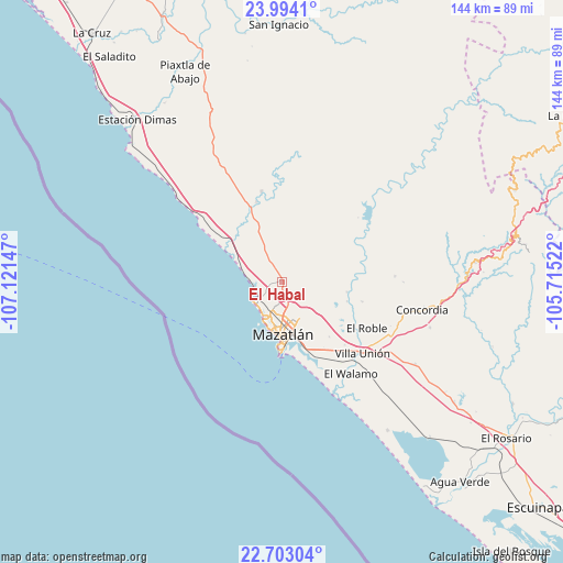
El Habal GPS coordinates[2]
23° 21' 0.504" North, 106° 25' 6.024" West
| Map corner | latitude | longitude |
|---|---|---|
| Upper-left | 23.9941°, | -107.12147° |
| Center: | 23.35014°, | -106.41834° |
| Lower-right: | 22.70304°, | -105.71522° |
| Map W x H: | 143.6×143.6 km | = 89.2×89.2mi |
| max Lat: | 32.7° ⇑11.3% North |
| El Habal: | 23.35014° |
| min Lat: | ⇓88.7% South 14.53588° |
| min Long | El Habal | max Long |
| -117.105° | -106.41834° | -86.73105° |
| W 5.9%⇐ | ⇒94.1% E |
Elevation
Elevation of El Habal is 64 m = 210 ft, and this is 1189.7 m = 3903 ft below average elevation for this country.
| Max E: |
3497 m = 11473 ft | 82.6% |
| Avg. | 1253.7 m = 4113 ft | |
| El Habal | 64 m = 210 ft | |
Min E: |
-1 m = -3 ft | 17.4% |
See also: Mexico elevation on elevation.city.
Geographical zone
El Habal is located in North Torrid zone (between Equator and Tropic of Cancer). Distance of this Northern Tropic circle is 9.6 km =6 mi to North.| Distance of | km | miles | from El Habal |
|---|---|---|---|
| North Pole | 7410.8 | 4604.9 | to North |
| Arctic Circle | 4804.9 | 2985.6 | to North |
| Tropic Cancer | 9.6 | 6 | to North |
| Equator | 2596.3 | 1613.3 | to South |


Nearby cities:
15 places around El Habal: (largest is in red/bold)
• El Bajío
21 km =13 mi,  103°
103°
• El Castillo
19 km =11.8 mi,  154°
154°
• El Quelite
23.8 km =14.8 mi,  347°
347°
• El Quemado
21.4 km =13.3 mi,  342°
342°
• El Recodo
21.9 km =13.6 mi,  73°
73°
• El Recreo
15.8 km =9.8 mi,  312°
312°
• El Vainillo
22.7 km =14.1 mi,  134°
134°
• Escamillas
19.6 km =12.2 mi,  116°
116°
• Fraccionamiento los Ángeles
20.1 km =12.5 mi, 153°
• La Noria de San Antonio
20.4 km =12.7 mi,  31°
31°
• Lomas de Monterrey
19.6 km =12.2 mi, 122°
• Mazatlán
13.1 km =8.1 mi,  174°
174°
• San Francisquito
20.7 km =12.9 mi, 125°
• Siqueros
18.1 km =11.2 mi,  92°
92°
• Tepuxta
23.4 km =14.5 mi, 72°
Sources, notices
• [Note1] Compared only with cities in Mexico existing in our database
• [Src1] Map data: © OpenStreetMap contributors (CC-BY-SA)
• [Src2] Other city data from geonames.org with taken over terms of usage.
• [Src3] Geographical zone / Annual Mean Temperature by Robert A. Rohde @ Wikipedia
