El Castillo geodata
El Castillo (Sinaloa) is a populated place; located in Mexico in America/Mazatlan (GMT-7) time zone. With population of 2,208 people, there are 3974 cities with bigger population in this country. Compared to other cities in Mexico, 88.4% of cities are located further ↓South; 94% of cities are located further →East and 94.6% of cities have higher elevation than El Castillo. Note1


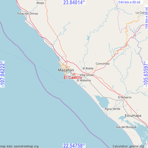
El Castillo GPS coordinates[2]
23° 11' 43.512" North, 106° 20' 20.724" West
| Map corner | latitude | longitude |
|---|---|---|
| Upper-left | 23.84014°, | -107.04222° |
| Center: | 23.19542°, | -106.33909° |
| Lower-right: | 22.54758°, | -105.63597° |
| Map W x H: | 143.7×143.7 km | = 89.3×89.3mi |
| max Lat: | 32.7° ⇑11.6% North |
| El Castillo: | 23.19542° |
| min Lat: | ⇓88.4% South 14.53588° |
| min Long | El Castillo | max Long |
| -117.105° | -106.33909° | -86.73105° |
| W 6%⇐ | ⇒94% E |
Elevation
Elevation of El Castillo is 14 m = 46 ft, and this is 1239.7 m = 4067 ft below average elevation for this country.
| Max E: |
3497 m = 11473 ft | 94.6% |
| Avg. | 1253.7 m = 4113 ft | |
| El Castillo | 14 m = 46 ft | |
Min E: |
-1 m = -3 ft | 5.4% |
See also: Mexico elevation on elevation.city.
Geographical zone
El Castillo is located in North Torrid zone (between Equator and Tropic of Cancer). Distance of this Northern Tropic circle is 26.8 km =16.7 mi to North.| Distance of | km | miles | from El Castillo |
|---|---|---|---|
| North Pole | 7428 | 4615.5 | to North |
| Arctic Circle | 4822.1 | 2996.3 | to North |
| Tropic Cancer | 26.8 | 16.7 | to North |
| Equator | 2579.1 | 1602.6 | to South |


Nearby cities:
15 places around El Castillo: (largest is in red/bold)
• Barrón
10.3 km =6.4 mi,  141°
141°
• El Bajío
17.5 km =10.9 mi,  44°
44°
• El Habal
19 km =11.8 mi,  334°
334°
• El Recodo
26.8 km =16.7 mi,  28°
28°
• El Roble
14.7 km =9.1 mi,  67°
67°
• El Vainillo
8.1 km =5 mi,  81°
81°
• El Walamo
11.4 km =7.1 mi,  122°
122°
• Escamillas
12.7 km =7.9 mi,  47°
47°
• Fraccionamiento los Ángeles
1.2 km =0.7 mi,  130°
130°
• Lomas de Monterrey
10.7 km =6.6 mi, 51°
• Malpica
22.3 km =13.9 mi, 73°
• Mazatlán
8 km =5 mi,  301°
301°
• San Francisquito
10.2 km =6.3 mi,  58°
58°
• Siqueros
19.1 km =11.9 mi, 31°
• Villa Unión
12.2 km =7.6 mi,  92°
92°
Sources, notices
• [Note1] Compared only with cities in Mexico existing in our database
• [Src1] Map data: © OpenStreetMap contributors (CC-BY-SA)
• [Src2] Other city data from geonames.org with taken over terms of usage.
• [Src3] Geographical zone / Annual Mean Temperature by Robert A. Rohde @ Wikipedia
